Файл:Sumatra.A2001190.0359 lrg.jpg
Исходный файл (4400 × 3400 пкс, размер файла: 1,81 МБ, MIME-тип: image/jpeg)
Этот файл находится на Викискладе. Сведения о нём показаны ниже.
Викисклад — централизованное хранилище для свободных файлов, используемых в проектах Викимедиа.
|
Краткое описание
- Source: NASA Visible Earth. [1]
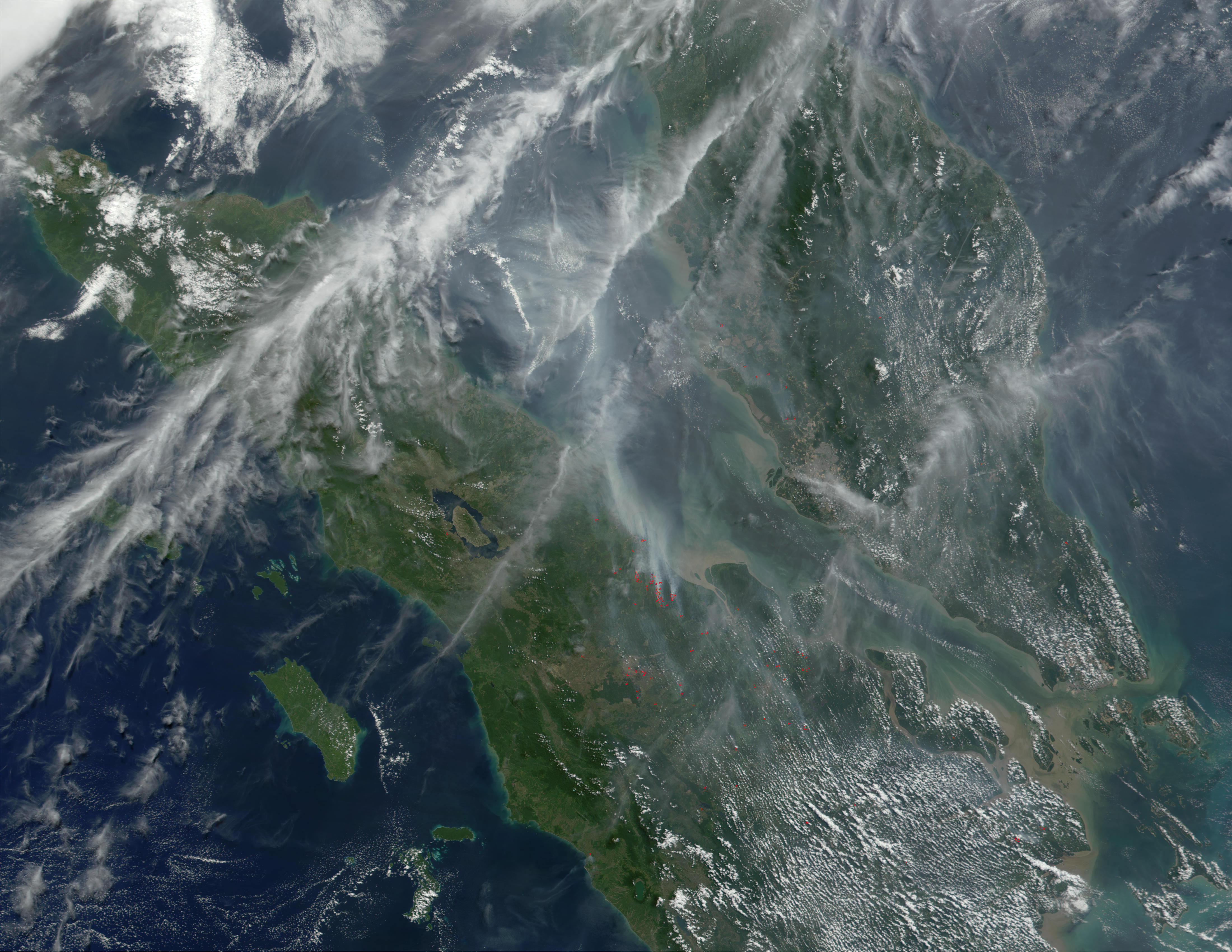
Haze over Malaysia
At least once a year for a period lasting from a week to several months, northern Sumatra is obscured by smoke and haze produced by agricultural burning and forest fires. These data products from the Multi-angle Imaging SpectroRadiometer (MISR) document the presence of airborne particulates on March 13, 2002. On the left is an image acquired by MISR’s 70-degree backward- viewing camera. On the right is a map of aerosol optical depth, a measure of the abundance of atmospheric particulates. This product utilized a test version of the MISR retrieval that incorporates an experimental set of aerosol mixtures. The haze has completely obscured northeastern Sumatra and part of the Strait of Malacca, which separates Sumatra and the Malaysian Peninsula. A northward gradient is apparent as the haze dissipates in the direction of the Malaysian landmass. Each panel covers an area of about 760 kilometers x 400 kilometers.
Haze conditions had posed a health concern during late February (when schools in some parts of North Sumatra were closed), and worsened considerably in the first two weeks of March. By mid-March, local meteorology officials asked residents of North Sumatra’s provincial capital, Medan, to minimize their outdoor activities and wear protective masks. Poor visibility at Medan airport forced a passenger plane to divert to Malaysia on March 14, and visibility reportedly ranged between 100 and 600 meters in some coastal towns southeast of Medan.
The number and severity of this year’s fires was exacerbated by dry weather conditions associated with the onset of a weak to moderate El Niño. The governments of Indonesia, Malaysia, and Brunei have agreed to ban open burning in plantation and forest areas. The enforcement of such fire bans, however, has proven to be an extremely challenging task.
Лицензирование
| Этот файл находится в общественном достоянии (англ. public domain), так как он был создан NASA (Национальным управлением по аэронавтике и исследованию космического пространства). Политика авторского права NASA гласит, что «Материал NASA не защищается авторским правом, если не указано иное». (См. Template:PD-USGov, страницу политики авторского права NASA или политику использования изображений JPL.) | ||
 |
Предупреждения:
|
История файла
Нажмите на дату/время, чтобы посмотреть файл, который был загружен в тот момент.
| Дата/время | Миниатюра | Размеры | Участник | Примечание | |
|---|---|---|---|---|---|
| текущий | 11:14, 7 октября 2005 | | 4400 × 3400 (1,81 МБ) | ChongDae | *Source: NASA Visible Earth. [http://visibleearth.nasa.gov/view_rec.php?id=1860] '''Haze over Malaysia''' At least once a year for a period lasting from a week to several months, northern Sumatra is obscured by smoke and haze produced by agricultural |
Использование файла
Нет страниц, использующих этот файл.
Глобальное использование файла
Данный файл используется в следующих вики:
- Использование в ar.wikipedia.org
- Использование в bn.wikipedia.org
- Использование в fr.wikipedia.org
- Использование в id.wikipedia.org
- Использование в it.wikipedia.org
- Использование в ko.wikipedia.org
- Использование в pl.wikipedia.org
- Использование в sr.wikipedia.org
- Использование в uk.wikipedia.org