Файл:Tana River, Kenya ESA23351187.tiff

Исходный файл (9340 × 9340 пкс, размер файла: 249,61 МБ, MIME-тип: image/tiff)
Этот файл находится на Викискладе. Сведения о нём показаны ниже.
Викисклад — централизованное хранилище для свободных файлов, используемых в проектах Викимедиа.
|
Краткое описание
| Внимание! | Изображение содержит очень большое количество пикселей, и при просмотре его в полном разрешении в некоторых обозревателях могут возникнуть такие проблемы, как загрузка искажённого изображения или зависание. |
|---|
| Описание |
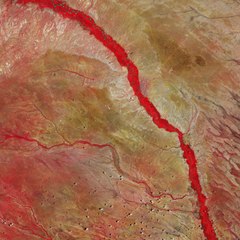
English: The Tana River, Kenya’s longest river, is featured in this false-colour image captured by the Copernicus Sentinel-2 mission. Zoom in to see this image at its full 10 m resolution or click on the circles to learn more about the features in it. The Tana River flows for around 1000 km from the Aberdare Mountains, west of Nyeri, running eastwards before veering south around the massif of Mount Kenya, and opening onto a wide valley, pictured here, where it meanders through a floodplain often subject to inundation. The river then continues its journey before entering the Indian Ocean at Formosa Bay, Kipini. The river is known for its extraordinary biodiversity, as it provides water and life for wild animals, nomads and their livestock, as well as for agricultural purposes. Some of the Tana’s tributaries as well as several smaller, seasonal rivers, known as lagas, that only flow during the rainy season, are visible flowing in an east-west direction in the image. The river beds support livestock and wildlife during the dry season owing to their ability to retain water. This false-colour image, captured on 25 February 2020, was processed in a way that included the near-infrared channel. This type of band combination from Copernicus Sentinel-2 is most commonly used to assess plant density and health, as plants reflect near-infrared and green light, while absorbing red. Since they reflect more near-infrared than green, dense, plant-covered land appears in bright red. It is easy to pick out the narrow band of riparian forest visible along the banks of the river in the image. The riparian forest usually thrives year-round, although its extent is highly dependent on seasonal flooding and ground water recharge by the Tana. This image was captured during the area’s wet season, where the small tributaries of the Tana are highly visible and a significant amount of vegetation can be seen. If the image had been captured during the dry season (around June-September), the smaller tributaries and the vegetation growing around them would have dried up. The river flows alongside the town of Garissa, the capital of Garissa County, and is visible as a greyish patch of land on the east side of the river. Around 5 km south of Garissa lies the Bour-Algi Giraffe Sanctuary, home to around 1000 giraffes and endangered wildlife including the Rothschild giraffe and gerenuk – a long-necked antelope found in the region. Copernicus Sentinel-2 is a two-satellite mission. Each satellite carries a high-resolution camera that images Earth’s surface in 13 spectral bands. The mission is mostly used to track changes in the way land is being used and to monitor the health of vegetation. This image is also featured on the Earth from Space video programme. |
| Дата | 18 июня 2021 (дата загрузки) |
| Источник | Tana River, Kenya |
| Автор | European Space Agency |
| Другие версии |
|
| Activity | Observing the Earth |
| Mission | Sentinel-2 |
| Set | Earth observation image of the week |
| System | Copernicus |

Лицензирование

|
This image contains data from a satellite in the Copernicus Programme, such as Sentinel-1, Sentinel-2 or Sentinel-3. Attribution is required when using this image.
Атрибуция: Contains modified Copernicus Sentinel data 2020
The use of Copernicus Sentinel Data is regulated under EU law (Commission Delegated Regulation (EU) No 1159/2013 and Regulation (EU) No 377/2014). Relevant excerpts:
Free access shall be given to GMES dedicated data [...] made available through GMES dissemination platforms [...].
Access to GMES dedicated data [...] shall be given for the purpose of the following use in so far as it is lawful:
GMES dedicated data [...] may be used worldwide without limitations in time.
GMES dedicated data and GMES service information are provided to users without any express or implied warranty, including as regards quality and suitability for any purpose. |
This media was created by the European Space Agency (ESA).
Where expressly so stated, images or videos are covered by the Creative Commons Attribution-ShareAlike 3.0 IGO (CC BY-SA 3.0 IGO) licence, ESA being an Intergovernmental Organisation (IGO), as defined by the CC BY-SA 3.0 IGO licence. The user is allowed under the terms and conditions of the CC BY-SA 3.0 IGO license to Reproduce, Distribute and Publicly Perform the ESA images and videos released under CC BY-SA 3.0 IGO licence and the Adaptations thereof, without further explicit permission being necessary, for as long as the user complies with the conditions and restrictions set forth in the CC BY-SA 3.0 IGO licence, these including that:
See the ESA Creative Commons copyright notice for complete information, and this article for additional details.
|
 | |
Этот файл доступен по лицензии Creative Commons Attribution-Share Alike 3.0 IGO. Атрибуция: ESA, CC BY-SA IGO 3.0
| ||
История файла
Нажмите на дату/время, чтобы посмотреть файл, который был загружен в тот момент.
| Дата/время | Миниатюра | Размеры | Участник | Примечание | |
|---|---|---|---|---|---|
| текущий | 10:31, 18 июня 2021 |  | 9340 × 9340 (249,61 МБ) | OptimusPrimeBot | #Spacemedia - Upload of https://esamultimedia.esa.int/img/2021/06/Tana_river_S2B_20200225_8-4-3_JW_crop.tif via Commons:Spacemedia |
Использование файла
Нет страниц, использующих этот файл.