Файл:The Xingu Indigenous Park, Mato Grosso, Brazil (MODIS 2019-05-22).jpg
Перейти к навигации
Перейти к поиску

Размер этого предпросмотра: 800 × 569 пкс. Другие разрешения: 320 × 228 пкс | 640 × 456 пкс | 1024 × 729 пкс | 1280 × 911 пкс | 2560 × 1822 пкс | 2883 × 2052 пкс.
Исходный файл (2883 × 2052 пкс, размер файла: 1,83 МБ, MIME-тип: image/jpeg)
Этот файл находится на Викискладе. Сведения о нём показаны ниже.
Викисклад — централизованное хранилище для свободных файлов, используемых в проектах Викимедиа.
|
.jpg?uselang=ru)
Краткое описание
| Описание |
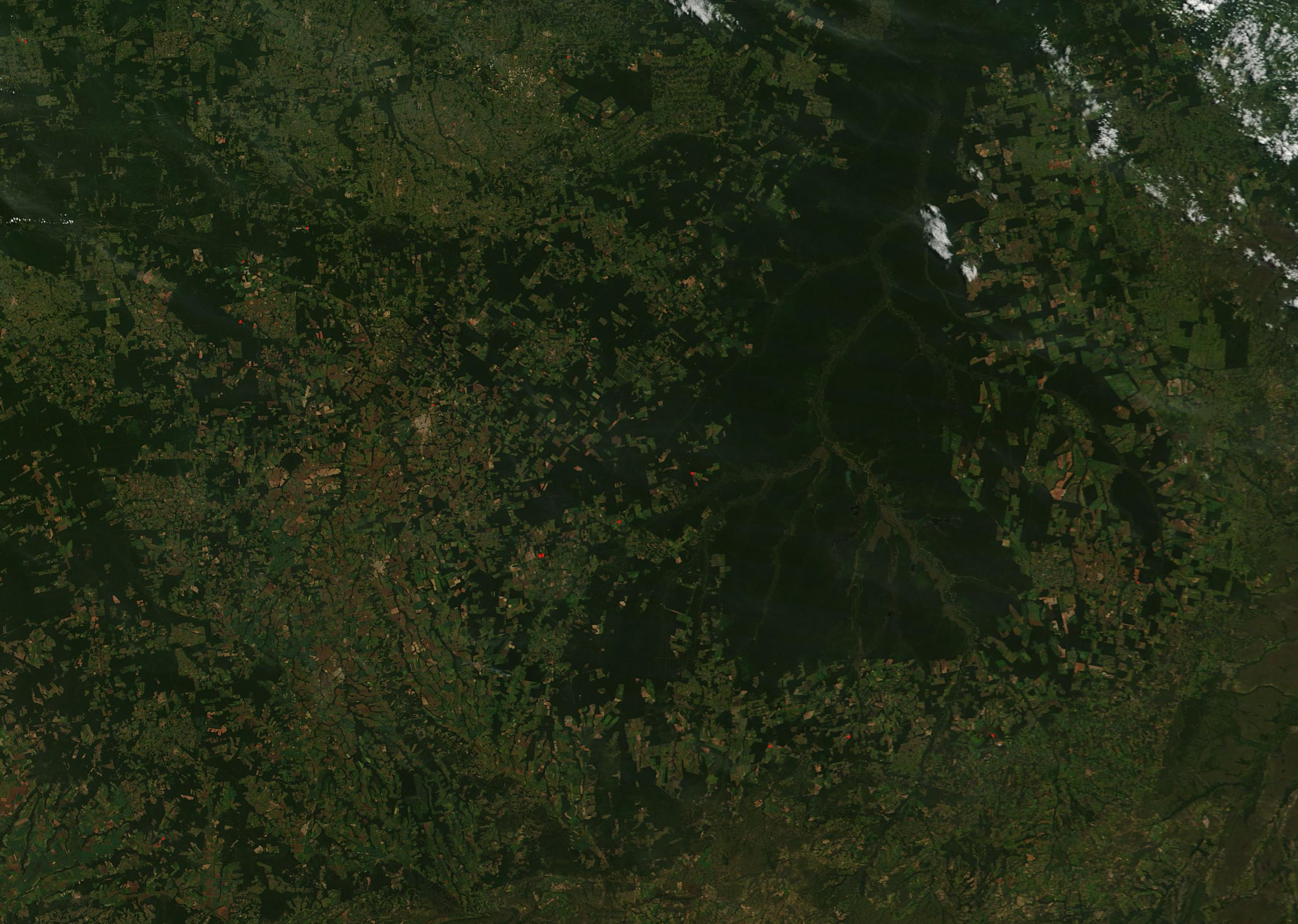
English: On the southern edge of the Amazon biome, in the northeast part of Mato Grosso state in Brazil, numerous rivers meet to form the large Xingu River. Approximately 2.64 million hectares of land surrounding that river were set aside in the early 1960s as a way to preserve biodiversity, maintain virgin rainforest and drier savanna and semi-deciduous forest, and the traditional way of life for several indigenous tribes. Today, the Xingu Indigenous Park is a bulwark against rampant deforestation which surrounds, and often attempts to encroach upon, the park.
On May 22, 2019, the Moderate Resolution Imaging Spectroradiometer (MODIS) on board NASA’s Terra satellite passed over Mato Grosso and acquired a true-color image that included the Xingu Indigenous Park and the surrounding countryside. The parkland appears dark green, marking thick vegetation and forest. Tan or slightly pink areas, which encompass most of the image, represent cleared land, most of which is being used for agriculture. Even though the agricultural burning season peaks in July-September, multiple fires were already burning in the region, creating a haze and streaks of smoke across the sky. |
||
| Дата | Снято: 22 мая 2019 | ||
| Источник |
The Xingu Indigenous Park, Mato Grosso, Brazil (direct link)
|
||
| Автор | MODIS Land Rapid Response Team, NASA GSFC |
| This media is a product of the Terra mission Credit and attribution belongs to the mission team, if not already specified in the "author" row |
Лицензирование
| Этот файл находится в общественном достоянии (англ. public domain), так как он был создан NASA (Национальным управлением по аэронавтике и исследованию космического пространства). Политика авторского права NASA гласит, что «Материал NASA не защищается авторским правом, если не указано иное». (См. Template:PD-USGov, страницу политики авторского права NASA или политику использования изображений JPL.) | ||
 |
Предупреждения:
|
История файла
Нажмите на дату/время, чтобы посмотреть файл, который был загружен в тот момент.
| Дата/время | Миниатюра | Размеры | Участник | Примечание | |
|---|---|---|---|---|---|
| текущий | 03:20, 17 февраля 2024 | | 2883 × 2052 (1,83 МБ) | OptimusPrimeBot | #Spacemedia - Upload of http://modis.gsfc.nasa.gov/gallery/images/image05222019_250m.jpg via Commons:Spacemedia |
Использование файла
Нет страниц, использующих этот файл.
.jpg)