Файл:TsunamiAftermathNorthofPhuket NASA.jpg
Перейти к навигации
Перейти к поиску

Размер этого предпросмотра: 647 × 599 пкс. Другие разрешения: 259 × 240 пкс | 518 × 480 пкс | 829 × 768 пкс | 1106 × 1024 пкс | 1987 × 1840 пкс.
Исходный файл (1987 × 1840 пкс, размер файла: 720 КБ, MIME-тип: image/jpeg)
Этот файл находится на Викискладе. Сведения о нём показаны ниже.
Викисклад — централизованное хранилище для свободных файлов, используемых в проектах Викимедиа.
|
Краткое описание
| Описание |
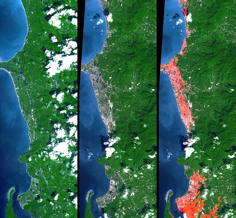
English: Simulated natural color images of a 27 kilometer long stretch of coast north of the Phuket Airport in the Khao Lak, Thailand on December 31 (middle) and two years earlier (left), showing changes to the coast caused by a tsunami. The image on the right is the image in the middle with red highlights of the changes. Additional details can be found at the source link. |
| Дата | November 15, 2002 and December 31, 2004 (ASTER), February 2000 (SRTM). See the source link for information about the individual photos |
| Источник | NASA Photojournal - http://photojournal.jpl.nasa.gov/catalog/PIA06671 |
| Автор |
ASTER: NASA/GSFC/METI/ERSDAC/JAROS, and U.S./Japan ASTER Science Team |
Лицензирование
| Этот файл находится в общественном достоянии (англ. public domain), так как он был создан NASA (Национальным управлением по аэронавтике и исследованию космического пространства). Политика авторского права NASA гласит, что «Материал NASA не защищается авторским правом, если не указано иное». (См. Template:PD-USGov, страницу политики авторского права NASA или политику использования изображений JPL.) | ||
 |
Предупреждения:
|
Исходный журнал загрузок
Первоначальная страница описания находилась здесь. Все нижеперечисленные имена участников относятся к en.wikipedia.
- 2005-04-16 17:22 SeanMack 1987×1840× (737390 bytes) PIA06671: Tsunami Inundation, North of Phuket, Thailand ASTER Images and SRTM Elevation Model NASA
История файла
Нажмите на дату/время, чтобы посмотреть файл, который был загружен в тот момент.
| Дата/время | Миниатюра | Размеры | Участник | Примечание | |
|---|---|---|---|---|---|
| текущий | 01:43, 2 января 2012 | | 1987 × 1840 (720 КБ) | File Upload Bot (Magnus Manske) | {{BotMoveToCommons|en.wikipedia|year={{subst:CURRENTYEAR}}|month={{subst:CURRENTMONTHNAME}}|day={{subst:CURRENTDAY}}}} {{Information |Description={{en|PIA06671: Tsunami Inundation, North of Phuket, Thailand ASTER Images and SRTM Elevation Model Source: |
Использование файла
Нет страниц, использующих этот файл.
Глобальное использование файла
Данный файл используется в следующих вики:
- Использование в de.wikipedia.org
- Использование в el.wikipedia.org
- Использование в en.wikipedia.org
- Использование в eo.wikipedia.org
- Использование в ko.wikipedia.org
- Использование в ms.wikipedia.org
- Использование в my.wikipedia.org
- Использование в pt.wikipedia.org
- Использование в tr.wikipedia.org
- Использование в www.wikidata.org