Файл:USACE Howell Heflin Lock and Dam.jpg
Перейти к навигации
Перейти к поиску

Размер этого предпросмотра: 800 × 558 пкс. Другие разрешения: 320 × 223 пкс | 640 × 447 пкс | 1024 × 715 пкс | 1280 × 893 пкс | 1500 × 1047 пкс.
Исходный файл (1500 × 1047 пкс, размер файла: 274 КБ, MIME-тип: image/jpeg)
Этот файл находится на Викискладе. Сведения о нём показаны ниже.
Викисклад — централизованное хранилище для свободных файлов, используемых в проектах Викимедиа.
|
| Описание |
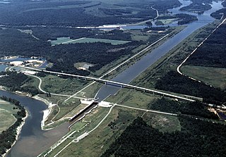
English: Aerial view of Howell Heflin Lock and Dam on the Tombigbee River, which is a part of the Tennessee-Tombigbee Waterway. The lock is located on a straightened and channelized section of the Waterway which bypasses a loop in the river. The associated dam (visible at top center) is actually located nearly two miles away on the original meandering path of the river. The lock and dam are part of the Tennessee-Tombigbee project, constructed by the U.S. Army Corps of Engineers for barge navigation from the Tennessee River to the Gulf of Mexico. The lock is located in Greene County, Alabama, near the town of Gainesville. The river here is the border between Greene County and Sumter County, and the dam spans the border between the two counties. Howell Heflin Lock is the lowest (farthest downriver) lock on the Tennessee-Tombigbee Waterway. View is upriver to the northwest.
Coordinates: 32°50′12.86″N 88°8′8.73″W / 32.8369056°N 88.1357583°W |
|||
| Место | Greene and Sumter Counties, Alabama, USA | |||
| Дата | (Caveat: Dates provided by U.S. Army Corps of Engineers Digital Visual Library are not reliable and may be wrong.) | |||
| Источник |
U.S. Army Corps of Engineers Digital Visual Library Image page Image description page Digital Visual Library home page |
|||
| Автор | Adrien Lamarre, U.S. Army Corps of Engineers | |||
| Права (Повторное использование этого файла) |
|
История файла
Нажмите на дату/время, чтобы посмотреть файл, который был загружен в тот момент.
| Дата/время | Миниатюра | Размеры | Участник | Примечание | |
|---|---|---|---|---|---|
| текущий | 19:27, 29 апреля 2007 | | 1500 × 1047 (274 КБ) | DanMS | {{Information | Description = {{en|Aerial view of Howell Heflin Lock and Dam on the Tombigbee River, which is a part of the Tennessee-Tombigbee Waterway. The lock is located on a straightened and channelized section of the Waterway which bypasses a loo |
Использование файла
Нет страниц, использующих этот файл.
Глобальное использование файла
Данный файл используется в следующих вики:
- Использование в el.wikipedia.org
- Использование в en.wikipedia.org
- Использование в hu.wikipedia.org
- Использование в ja.wikipedia.org
- Использование в ro.wikipedia.org
- Использование в www.wikidata.org