Файл:Venus Aine Corona.jpg

Исходный файл (1000 × 784 пкс, размер файла: 401 КБ, MIME-тип: image/jpeg)
Этот файл находится на Викискладе. Сведения о нём показаны ниже.
Викисклад — централизованное хранилище для свободных файлов, используемых в проектах Викимедиа.
|
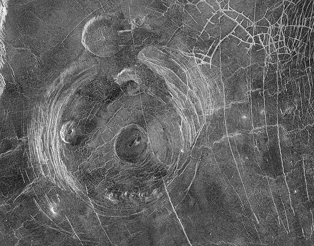
Original Caption Released with Image:
This Magellan radar image shows a region approximately 300 kilometers (180 miles) across, centered on 59 degrees south latitude, 164 degrees east longitude and located in a vast plain to the south of Aphrodite Terra. The data for this image was obtained in January 1991. The large circular structure near the center of the image is a corona, approximately 200 kilometers (120 miles) in diameter and provisionally named Aine Corona. Just north of Aine Corona is one of the flat-topped volcanic constructs known as 'pancake' domes for their shape and flap-jack appearance. This pancake dome is about 35 kilometers (21 miles) in diameter and is thought to have formed by the eruption of an extremely viscous lava. Another pancake dome is located inside the western parts of the annulus of the corona fractures. Complex fracture patterns like the one in the upper right of the image are often observed in association with coronae and various volcanic features. They are thought to form because magma beneath the surface follows pre-existing fracture patterns. When eruptions or other movements of the magma occur, the magma drains from the fractures and the overlying surface rock collapses. Other volcanic features associated with Aine Corona include a set of small domes, each less than 10 kilometers (6 miles) across, located along the southern portion of the annulus of fractures, and a smooth, flat region in the center of the corona, probably a relatively young lava flow. The range of volcanic features associated with coronae suggests that volcanism plays a significant role in their formation.
Image Note: F-MIDR 59S164
Source: http://photojournal.jpl.nasa.gov/catalog/PIA00202
Это изображение или видеозапись внесены в каталог Лаборатории реактивного движения НАСА под идентификатором (Photo ID): PIA00202. Этот шаблон не указывает на правовой статус данной работы. По-прежнему необходим нормальный шаблон лицензий. См. Commons:Лицензирование. Другие языки:
|
| Этот файл находится в общественном достоянии (англ. public domain), так как он был создан NASA (Национальным управлением по аэронавтике и исследованию космического пространства). Политика авторского права NASA гласит, что «Материал NASA не защищается авторским правом, если не указано иное». (См. Template:PD-USGov, страницу политики авторского права NASA или политику использования изображений JPL.) | ||
 |
Предупреждения:
|
История файла
Нажмите на дату/время, чтобы посмотреть файл, который был загружен в тот момент.
| Дата/время | Миниатюра | Размеры | Участник | Примечание | |
|---|---|---|---|---|---|
| текущий | 10:47, 6 августа 2005 | | 1000 × 784 (401 КБ) | Vzb83~commonswiki | '''Original Caption Released with Image:''' This Magellan radar image shows a region approximately 300 kilometers (180 miles) across, centered on 59 degrees south latitude, 164 degrees east longitude and located in a vast plain to the south of Aphrodite |
Использование файла
Нет страниц, использующих этот файл.
Глобальное использование файла
Данный файл используется в следующих вики:
- Использование в fi.wikipedia.org