Файл:View from Smithsonian Butte facing north along old road - Zion National Park Roads and Bridges, Springdale, Washington County, UT HAER UTAH,27-SPDA.V,9-5.tif
Перейти к навигации
Перейти к поиску

Размер этого JPG-превью для исходного TIF-файла: 800 × 576 пкс. Другие разрешения: 320 × 230 пкс | 640 × 460 пкс | 1024 × 737 пкс | 1280 × 921 пкс | 2560 × 1842 пкс | 5000 × 3597 пкс.
Исходный файл (5000 × 3597 пкс, размер файла: 17,15 МБ, MIME-тип: image/tiff)
Этот файл находится на Викискладе. Сведения о нём показаны ниже.
Викисклад — централизованное хранилище для свободных файлов, используемых в проектах Викимедиа.
|
Краткое описание
| View from Smithsonian Butte facing north along old road - Zion National Park Roads and Bridges, Springdale, Washington County, UT | ||||
|---|---|---|---|---|
| Фотограф |
Grogan, Brian C., creator |
|||
| Название |
View from Smithsonian Butte facing north along old road - Zion National Park Roads and Bridges, Springdale, Washington County, UT |
|||
| Описание |
Bureau of Public Roads; Utah State Road Commission; Arizona State Road Commission; Albright, Horace; Tufts, William O; Mather, Stephen T; Nevada Contracting Company; Raleigh-Lang Construction Company; Reynolds-Ely Construction Company; Union Pacific Railroad; Anderson, Michael F, historian; Grogan, Brian C, photographer |
|||
| Изображённое место | Utah; Washington County; Springdale | |||
| Дата | 1993 | |||
| Размеры | 5 x 7 in. | |||
| Текущее местонахождение |
Library of Congress Prints and Photographs Division Washington, D.C. 20540 USA http://hdl.loc.gov/loc.pnp/pp.print |
|||
| Инвентарный номер |
HAER UTAH,27-SPDA.V,9-5 |
|||
| Дополнительная информация |
|
|||
| Примечания |
|
|||
| Источник | https://www.loc.gov/pictures/item/ut0400.photos.367608p | |||
| Права (Повторное использование этого файла) |
|
|||

История файла
Нажмите на дату/время, чтобы посмотреть файл, который был загружен в тот момент.
| Дата/время | Миниатюра | Размеры | Участник | Примечание | |
|---|---|---|---|---|---|
| текущий | 02:14, 4 августа 2014 | 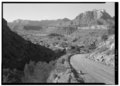 | 5000 × 3597 (17,15 МБ) | Fæ | GWToolset: Creating mediafile for Fæ. HABS 2014-08-02 (3401:3600) |
Использование файла
Нет страниц, использующих этот файл.