Файл:WV plateau.jpg

Исходный файл (800 × 784 пкс, размер файла: 472 КБ, MIME-тип: image/jpeg)
Этот файл находится на Викискладе. Сведения о нём показаны ниже.
Викисклад — централизованное хранилище для свободных файлов, используемых в проектах Викимедиа.
|
Перенесено с en.wikipedia на Викисклад участником Maksim.
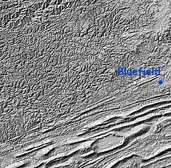
Relief Map: Cumberland Plateau, West Virginia and "Ridge and Valley" region of Virginia
Image is Shaded Relief Imagery, derived from the US Geological Survey National Elevation Dataset, modified by Pollinator. USGS-authored or produced data and information are in the public domain.
(Point of reference: Bluefield, West Virginia is on the Virginia/West Virginia border)
On the southeastern portion of this map is the folded Appalachians of Virginia, also known as the Ridge-and-valley Appalachians, which are the roots of true ancient mountains, uplifted once again, with the harder rock layers forming ridges and the more erodable rocks becoming valleys.
A major fault line runs from southwest to northeast dividing the folded mountains from the Cumberland Plateau of West Virginia, a dissected plateau that forms the majority of the image. This area of sedimentary rock (including many coal) veins is, geologically speaking, not true mountains, but merely was uplifted and eroded. Note that the area is actually more rugged than the folded mountains, though not as high.
Это изображение находится в общественном достоянии, так как содержит материалы, которые первоначально получены от Геологической службы США (USGS) — агентства Министерства внутренних дел США. Дополнительную информацию см. «Официальная политика авторского права USGS» (англ.).
|
| date/time | username | edit summary |
|---|---|---|
| 01:20, 12 February 2005 | en:User:RedWolf | ({{PD-USGov-Interior-USGS}}) |
| 06:23, 8 November 2004 | en:User:SimonP | |
| 20:08, 21 August 2004 | en:User:Pollinator | (tweak and wikify) |
| 19:55, 21 August 2004 | en:User:Pollinator | (public domain) |
| 19:52, 21 August 2004 | en:User:Pollinator | (link repair) |
| 19:50, 21 August 2004 | en:User:Pollinator | (Photo caption) |
| 19:38, 21 August 2004 | en:User:Pollinator | (Relief Map: Cumberland Plateau, West Virginia and "Ridge and Valley" region of Virginia) |
Исходный журнал загрузок
Legend: (cur) = this is the current file, (del) = delete this old version, (rev) = revert to this old version.
Click on date to download the file or see the image uploaded on that date.
- (del) (cur) 19:38, 21 August 2004 . . en:User:Pollinator Pollinator ( en:User_talk:Pollinator Talk) . . 800x784 (483656 bytes) (Relief Map: Cumberland Plateau, West Virginia and "Ridge and Valley" region of Virginia)
История файла
Нажмите на дату/время, чтобы посмотреть файл, который был загружен в тот момент.
| Дата/время | Миниатюра | Размеры | Участник | Примечание | |
|---|---|---|---|---|---|
| текущий | 18:47, 5 февраля 2006 | | 800 × 784 (472 КБ) | Maksim | La bildo estas kopiita de wikipedia:en. La originala priskribo estas: Relief Map: Cumberland Plateau, West Virginia and "Ridge and Valley" region of Virginia Image is Shaded Relief Imagery, derived from the US Geological Survey National Elevation Datase |
Использование файла
Нет страниц, использующих этот файл.
Глобальное использование файла
Данный файл используется в следующих вики:
- Использование в ca.wikipedia.org
- Использование в da.wikipedia.org
- Использование в en.wikipedia.org
- Использование в eo.wikipedia.org
- Использование в es.wikipedia.org
- Использование в it.wikipedia.org
- Использование в ja.wikipedia.org
- Использование в nn.wikipedia.org
- Использование в pt.wikipedia.org