Файл:Wesergeb34.jpg
Перейти к навигации
Перейти к поиску

Размер этого предпросмотра: 450 × 600 пкс. Другие разрешения: 180 × 240 пкс | 576 × 768 пкс.
Исходный файл (576 × 768 пкс, размер файла: 295 КБ, MIME-тип: image/jpeg)
Этот файл находится на Викискладе. Сведения о нём показаны ниже.
Викисклад — централизованное хранилище для свободных файлов, используемых в проектах Викимедиа.
|
Краткое описание
| Описание |
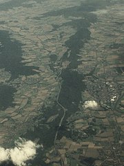
Deutsch: Luftaufnahme des Wesergebirges von Westen. Der annähernd in Ost-West-Richtung verlaufende Kamm des Wesergebirges ist anhand seiner Bewaldung gut auszumachen. Links (nördlich des Kammes) im Vordergrund Kleinenbremen (Ortsteil von Porta Westfalica) und dahinter Bad Eilsen. Die Waldfläche noch unterhalb (westlich) von Bad Eilsen am linken Bildrand markiert den Harrl. Die größere Waldfläche oberhalb (östlich) von Bad Eilsen am linken Bildrand markiert den Bückeberg. Rechts (südlich des Kammes des Wesergebirges) im Vordergrund Eisbergen (ebenfalls ein Ortsteil von Porta Westfalica) und dahinter Rinteln. Auf höhe Rinteln sind am rechten Bildrand zwei Mäander der Weser erkennbar. Im Bildhintergrund ist der Übergang des annähernd ost-west-streichenden Wesergebirges in den südost-nordwest-streichenden Süntel zu sehen. Die Waldfläche in der oberen linken Bildecke ist der Deister. Im Bildvordergrund kreuzt die A2 schräg den Kamm des Wesergebirges. Von links nach rechts (Norden nach Süden) schlängelt sich die Grenze zwischen Nordrhein-Westfalen und Niedersachsen durch das Bild. Sie verläuft zwischen den beiden Ortsteilen von Porta Westfalica und Bad Eilsen bzw. Rinteln.
English: Aerial photograph of the Wesergebirge ridge, looking from the west. The forested crest of the approximately east-west trending ridge is well visible. The settlement in the foreground left (north) of the crest is Kleinenbremen (an administrative subdivision of Porta Westfalica) and the settlement somewhat further back is the town of Bad Eilsen. The forested area below (west of) Bad Eilsen at the left margin of the photo marks the Harrl hill. The forested area above (east of) Bad Eilsen at the left margin of the photo marks the Bückeberg ‘massif’. The settlement in the foreground right (south) of the crest of the Wesergebirge ridge is Eisbergen (another administrative subdivision of Porta Westfalica) and the settlement somewhat further back ist the town of Rinteln. Close to Rinteln at the right margin of the image two bends of the Weser river are fairly visible. Towards the background of the photo the transition from the approximately east-west trending Wesergebirge ridge to the southeast-northwest trending Süntel ‘massif’ is visible. The forested area in the top left corner represents the Deister ‘massif’. In the foreground the Autobahn A2 is obliquely crossing the the crest of the Wesergebirge ridge. From the left to the right (north to the south) the border between North Rhine Westphalia and Lower Saxony is meandering across the photo. It runs between the two subdivisions of Porta Westfalica and the towns of Bad Eilsen and Rinteln, respectively. |
| Дата |
16 февраля 2007 (дата первоначальной загрузки файла на вики) |
| Источник | Собственная работа (Исходный текст: eigene Aufnahme) |
| Автор | TILMAN KLUGE 08:49, 16. Feb. 2007 (CET) |
| Местоположение камеры | | Это и другие изображения по их местоположению на OpenStreetMap |
|---|
Лицензирование

|
Разрешается копировать, распространять и/или изменять этот документ в соответствии с условиями GNU Free Documentation License версии 1.2 или более поздней, опубликованной Фондом свободного программного обеспечения, без неизменяемых разделов, без текстов, помещаемых на первой и последней обложке. Копия лицензии включена в раздел, озаглавленный GNU Free Documentation License. |
| Этот файл доступен по лицензии Creative Commons Attribution-Share Alike 3.0 Unported. | ||
| ||
| Этот признак лицензирования был добавлен к этому файлу как часть обновления лицензии GFDL. |
Исходный журнал загрузок
Первоначальная страница описания находилась здесь. Все нижеперечисленные имена участников относятся к de.wikipedia.
- 2007-02-16 07:49 TILMAN KLUGE 576×768× (302098 bytes) {{Information |Beschreibung=Wesergebirge von Westen, rechts Rintel,, links Bad Eilsen, Hintergrund Weserbergland |Quelle=eigene Aufnahme |Urheber=~~~~ |Datum= |Genehmigung= |Andere Versionen= |Anmerkungen= }}
| Аннотации | Это изображение аннотировано: Просмотреть аннотации на Викискладе |
История файла
Нажмите на дату/время, чтобы посмотреть файл, который был загружен в тот момент.
| Дата/время | Миниатюра | Размеры | Участник | Примечание | |
|---|---|---|---|---|---|
| текущий | 15:18, 11 февраля 2009 | | 576 × 768 (295 КБ) | TUBS | {{Information |Description={{de|Wesergebirge von Westen, rechts de:Rinteln, links de:Bad Eilsen, Hintergrund de:Weserbergland}} |Source=Transferred from [http://de.wikipedia.org de.wikipedia]<br/> (Original text : ''eigene Aufnahme'') |Date |
Использование файла
Нет страниц, использующих этот файл.
Глобальное использование файла
Данный файл используется в следующих вики:
- Использование в de.wikipedia.org
- Использование в en.wikipedia.org
- Использование в et.wikipedia.org
- Использование в mk.wikipedia.org