Файл:Cassini-OntarioLacus-RADAR.jpg

Исходный файл (1411 × 1276 пкс, размер файла: 329 Кб, MIME-тип: image/jpeg)
Этот файл находится на Викискладе. Сведения о нём показаны ниже.
Викисклад — централизованное хранилище для свободных файлов, используемых в проектах Викимедиа.
|
Краткое описание
| Описание |
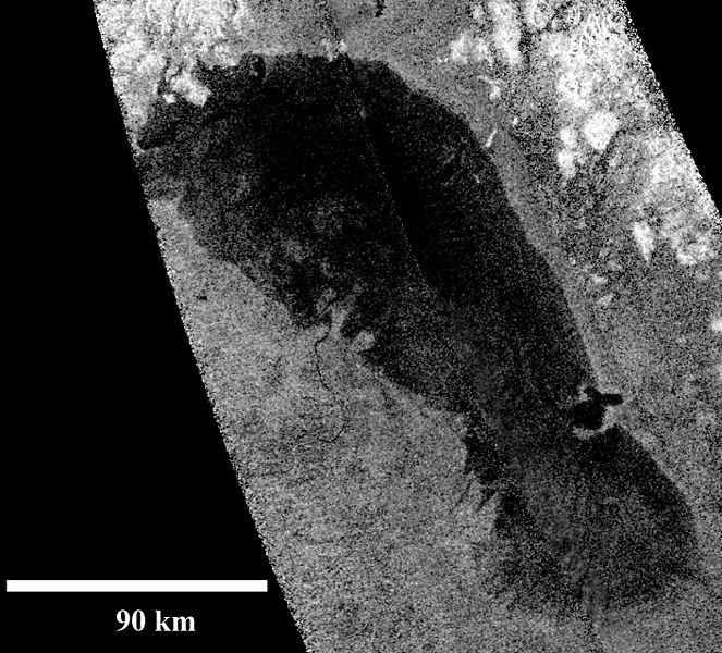
English: This RADAR-image of Ontario Lacus, the largest lake on the southern hemisphere of Saturn's moon Titan, was obtained by NASA's Cassini spacecraft on Jan. 12, 2010. North is up in this image.
Objects appear bright in this radar image when they are tilted toward the spacecraft or have rough surfaces. The lake surface appears dark because it is smooth. The northern shoreline features flooded river valleys and hills as high as 1 kilometer (3,000 feet) in altitude. A smooth, wave-sculpted shoreline, like that seen on the southeastern side of Lake Michigan, can be seen at the northeastern part of the lake. Smooth lines parallel to the current shoreline could be formed by low waves over time, which were likely driven by winds sweeping in from the west or southwest. The southeast shore features a round-headed bay intruding into the shore. The liquid-filled depressions appear to be relatively recent. The middle part of the western shoreline shows the first well-developed delta observed on Titan. The shape of the delta shows that liquid flowing down from a higher plain has switched channels on its way into the lake, forming at least two lobes. Examples of this kind of channel switching and wave-modified deltas can be found on Earth at the southern end of Lake Albert between Uganda and the Democratic Republic of Congo in Africa and the remains of an ancient lake known as Megachad in the African country Chad.Deutsch: Radarabtastung des Ontario Lacus, des größten Ethan-Methan-Sees auf der Südhalbkugel des größten Saturnmondes Titan aufgenommen durch die Raumsonde Cassini am 12. Januar, 2010.
Das nördliche Ufer ist geprägt durch ca. 1 km hohe Hügel sowie überflutete Flusstäler. Eine gerade verlaufende, wellengeformte Küstenlinie, ähnlich der des südwestlichen Michigansees, kann im nordöstlichen Bereich beobachtet werden. Parallel zum gegenwärtigen Ufer verlaufende Linien könnten über längere Zeiträume durch niedrige Wellen geformt worden sein, welche wiederum vermutlich aufgrund von West- oder Südwestwinden entstehen. Die südöstliche Küste zeigt eine rundliche, weit in den See ragende Bucht. Der mittlere Teil der westlichen Küste weist das erste beobachtete und gut ausgeprägte Flussdelta auf Titan auf. Ähnlich dem Rhône-Delta in der französischen Camargue, handelt es sich seiner Morphologie nach zu urteilen um ein wellendominiertes Delta, bei dem von höherliegenden Gebieten kommende flüssige Kohlenwasserstoffe auf ihrem Weg zum See ihre Flussrinne wechseln und so mindestens zwei Halbinseln geschaffen haben. Weitere Beispiele solcher Rinnenwechsel bzw. wellendominierter Deltas können auf der Erde am südlichen Ende des Albertsees in Afrika zwischen Uganda und der Demokratischen Republik Kongo sowie als Überreste des einstigen Binnenmeeres Mega-Tschad im Tschad gefunden werden. |
| Дата | |
| Источник | http://photojournal.jpl.nasa.gov/catalog/PIA13172 |
| Автор | NASA/JPL-Caltech |
Лицензирование
| Этот файл находится в общественном достоянии (англ. public domain), так как он был создан NASA (Национальным управлением по аэронавтике и исследованию космического пространства). Политика авторского права NASA гласит, что «Материал NASA не защищается авторским правом, если не указано иное». (См. Template:PD-USGov, страницу политики авторского права NASA или политику использования изображений JPL.) | ||
 |
Предупреждения:
|
История файла
Нажмите на дату/время, чтобы посмотреть файл, который был загружен в тот момент.
| Дата/время | Миниатюра | Размеры | Участник | Примечание | |
|---|---|---|---|---|---|
| текущий | 18:08, 22 июля 2010 | | 1411 × 1276 (329 Кб) | 36ophiuchi~commonswiki | {{Information |Description={{en|1= This RADAR-image of Ontario Lacus, the largest lake on the southern hemisphere of Saturn's moon Titan, was obtained by NASA's Cassini spacecraft on Jan. 12, 2010. North is up in this image. Objects appear bright |
Использование файла
Следующая страница использует этот файл:
Глобальное использование файла
Данный файл используется в следующих вики:
- Использование в ar.wikipedia.org
- Использование в ca.wikipedia.org
- Использование в cs.wikipedia.org
- Использование в de.wikipedia.org
- Использование в en.wikipedia.org
- Использование в en.wiktionary.org
- Использование в fr.wikipedia.org
- Использование в hr.wikipedia.org
- Использование в id.wikipedia.org
- Использование в it.wikipedia.org
- Использование в it.wikibooks.org
- Использование в it.wikiversity.org
- Использование в ja.wikipedia.org
- Использование в ko.wikipedia.org
- Использование в lb.wikipedia.org
- Использование в nn.wikipedia.org
- Использование в no.wikipedia.org
- Использование в pl.wikipedia.org
- Использование в pt.wikipedia.org
- Использование в www.wikidata.org