Файл:Ice Floes off the Northeastern Tip of Urup Island, Russia.jpg
Исходный файл (4288 × 2848 пкс, размер файла: 3,03 МБ, MIME-тип: image/jpeg)
Этот файл находится на Викискладе. Сведения о нём показаны ниже.
Викисклад — централизованное хранилище для свободных файлов, используемых в проектах Викимедиа.
|
Краткое описание
| Описание |
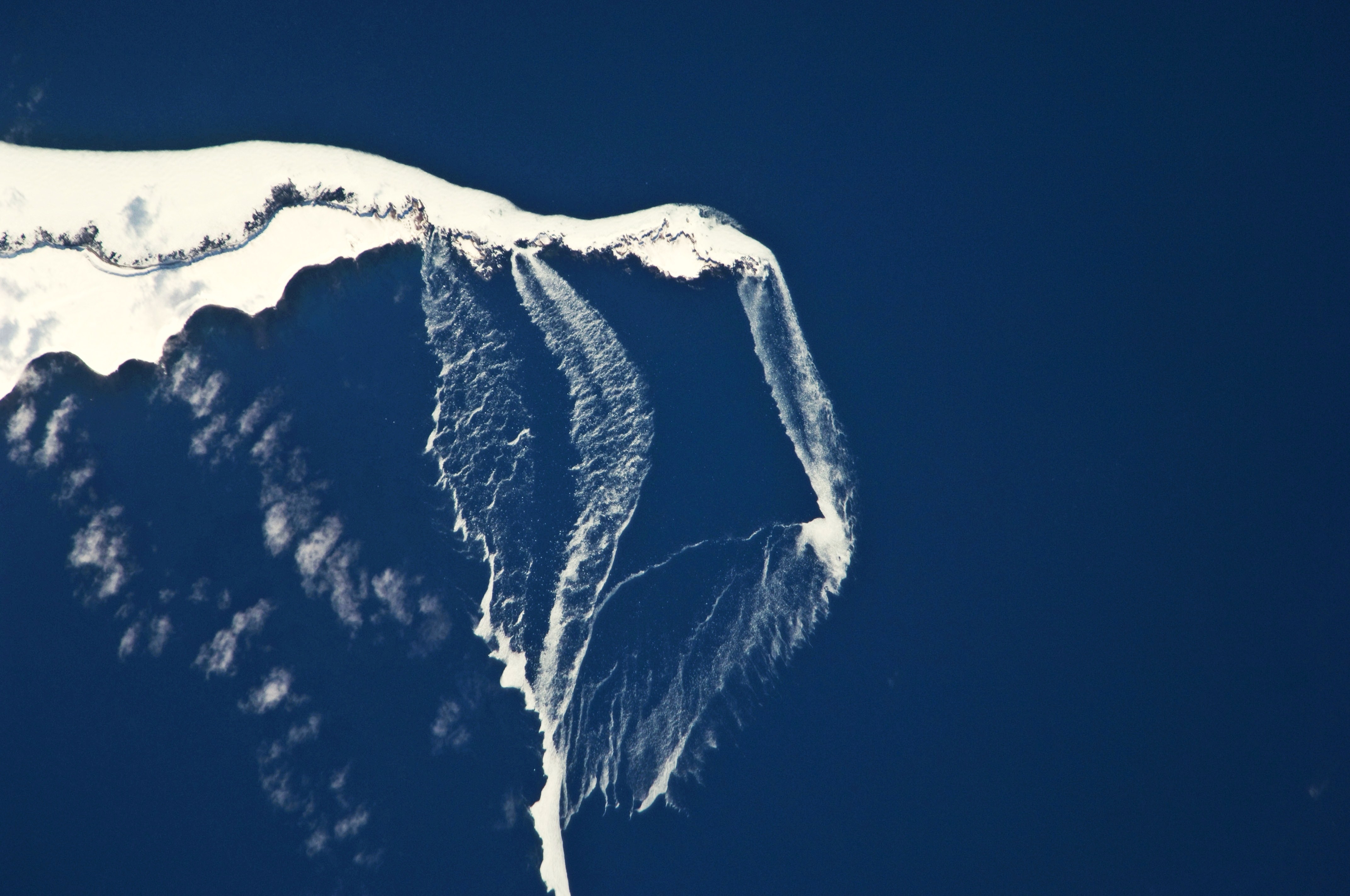
English: The north-eastern tip of the island and three small islands to the north-east are recognizable by their uniform cover of white snow and shadowing along the north-western coastlines. Sea ice that formed to the north in the Sea of Okhotsk has been piled up against the islands by prevailing north-westerly winds, forming an irregular mass connecting the islands (image centre). The orientation of patchy low clouds over Urup Island (image lower left) also suggests that north-westerly winds are present. Smaller ice floes are breaking off from the main ice mass at gaps between the islands and forming finger-like projections of ice fragments that extend to the south-east (image lower right). Surface winds may be channelled through these gaps and accelerated, hastening the breakup and movement of ice. |
| Дата | |
| Источник | NASA Earth Observatory |
| Автор | Image captured by the NASA Expedition 23 crew |
Image acquired with a Nikon D2Xs digital camera fitted with an 800 mm lens, and is provided by the ISS Crew Earth Observations experiment and Image Science & Analysis Laboratory, Johnson Space Center. Center Point Latitude: 46.2 Center Point Longitude: 150.6 (Negative numbers indicate south for latitude and west for longitude). Camera Tilt: 13 Camera Focal Length: 800mm Camera: N2: Nikon D2Xs Film: 4288E : 4288 x 2848 pixel CMOS sensor, RGBG imager color filter. Nadir Point Latitude: 46.4, Longitude: 151.3 (Negative numbers indicate south for latitude and west for longitude) Nadir to Photo Center Direction: West Sun Azimuth: 127 (Clockwise angle in degrees from north to the sun measured at the nadir point) Spacecraft Altitude: 183 nautical miles (339 km) Sun Elevation Angle: 35 (Angle in degrees between the horizon and the sun, measured at the nadir point).
Лицензирование
| Этот файл находится в общественном достоянии (англ. public domain), так как он был создан NASA (Национальным управлением по аэронавтике и исследованию космического пространства). Политика авторского права NASA гласит, что «Материал NASA не защищается авторским правом, если не указано иное». (См. Template:PD-USGov, страницу политики авторского права NASA или политику использования изображений JPL.) | ||
 |
Предупреждения:
|
| Аннотации | Это изображение аннотировано: Просмотреть аннотации на Викискладе |
История файла
Нажмите на дату/время, чтобы посмотреть файл, который был загружен в тот момент.
| Дата/время | Миниатюра | Размеры | Участник | Примечание | |
|---|---|---|---|---|---|
| текущий | 12:36, 19 апреля 2010 | | 4288 × 2848 (3,03 МБ) | Originalwana | {{Information |Description={{en|1=The north-eastern tip of the island and three small islands to the north-east are recognizable by their uniform cover of white snow and shadowing along the north-western coastlines. [[:C |
Использование файла
Следующая страница использует этот файл:
Глобальное использование файла
Данный файл используется в следующих вики:
- Использование в az.wikipedia.org
- Использование в bg.wikipedia.org
- Использование в en.wikipedia.org
- Использование в gl.wikipedia.org
- Использование в it.wikipedia.org