Файл:Lakshmi Planum and Siddons Patera PIA00240.jpg
Перейти к навигации
Перейти к поиску

Размер этого предпросмотра: 507 × 599 пкс. Другие разрешения: 203 × 240 пкс | 406 × 480 пкс | 650 × 768 пкс | 866 × 1024 пкс | 1732 × 2048 пкс | 3073 × 3633 пкс.
Исходный файл (3073 × 3633 пкс, размер файла: 3,76 Мб, MIME-тип: image/jpeg)
Этот файл находится на Викискладе. Сведения о нём показаны ниже.
Викисклад — централизованное хранилище для свободных файлов, используемых в проектах Викимедиа.
|
Краткое описание
| Описание |
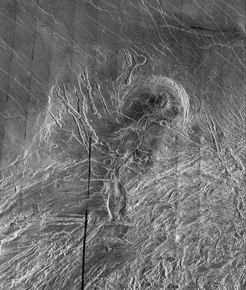
English: This image is a full-resolution mosaic of several Magellan images and is centered at 61 degrees north latitude and 341 degrees east longitude. The image is 250 kilometers wide (150 miles). The radar smooth region in the northern part of the image is Lakshmi Planum, a high plateau region roughly 3.5 kilometers (2.2 miles) above the mean planetary radius. Lakshmi Planum is ringed by intensely deformed terrain, some of which is shown in the southern portion of the image and is called Clotho Tessera. The 64-kilometer (40 mile) diameter circular feature in the image is a depression called Siddons and may be a volcanic caldera. This view is supported by the collapsed lava tubes surrounding the feature. By carefully studying this and other surrounding images scientists hope to discover what tectonic and volcanic processes formed this complex region. The solid black parts of the image represent data gaps that may be filled in by the Magellan extended mission. |
| Источник | http://photojournal.jpl.nasa.gov/catalog/PIA00240 |
| Автор | Galileo probe |
Лицензирование
| Этот файл находится в общественном достоянии (англ. public domain), так как он был создан NASA (Национальным управлением по аэронавтике и исследованию космического пространства). Политика авторского права NASA гласит, что «Материал NASA не защищается авторским правом, если не указано иное». (См. Template:PD-USGov, страницу политики авторского права NASA или политику использования изображений JPL.) | ||
 |
Предупреждения:
|
История файла
Нажмите на дату/время, чтобы посмотреть файл, который был загружен в тот момент.
| Дата/время | Миниатюра | Размеры | Участник | Примечание | |
|---|---|---|---|---|---|
| текущий | 05:38, 7 апреля 2008 | | 3073 × 3633 (3,76 Мб) | Bryan Derksen | {{Information |Description={{en|This image is a full-resolution mosaic of several Magellan images and is centered at 61 degrees north latitude and 341 degrees east longitude. The image is 250 kilometers wide (150 miles). The radar smooth region in the nor |
Использование файла
Следующая страница использует этот файл:
Глобальное использование файла
Данный файл используется в следующих вики:
- Использование в be.wikipedia.org
- Использование в bn.wikipedia.org
- Использование в cs.wikipedia.org
- Использование в fi.wikipedia.org
- Использование в fr.wikipedia.org
- Использование в hi.wikipedia.org
- Использование в hy.wikipedia.org
- Использование в ja.wikipedia.org
- Использование в nl.wikipedia.org
- Использование в sr.wikipedia.org
- Использование в ta.wikipedia.org
- Использование в uk.wikipedia.org
- Использование в zh.wikipedia.org