Файл:Landsat GlacierBay 01aug99.jpg
Перейти к навигации
Перейти к поиску

Размер этого предпросмотра: 800 × 480 пкс. Другие разрешения: 320 × 192 пкс | 1024 × 614 пкс | 1280 × 768 пкс | 2560 × 1536 пкс | 7500 × 4500 пкс.
Исходный файл (7500 × 4500 пкс, размер файла: 4,04 МБ, MIME-тип: image/jpeg)
Этот файл находится на Викискладе. Сведения о нём показаны ниже.
Викисклад — централизованное хранилище для свободных файлов, используемых в проектах Викимедиа.
|
Краткое описание
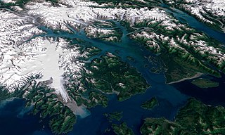
| Описание | 3D visualization of Landsat imagery of Glacier Bay National Park and Preserve |
| Дата | |
| Источник | Visible Earth - http://visibleearth.nasa.gov/view_rec.php?id=16657 |
| Автор | Landsat Project Science Office at NASA’s Goddard Space Flight Center |
| Права (Повторное использование этого файла) |
PD |
From the source page:
- The water in the foreground in the southwest (bottom left) corner of the image is the Gulf of Alaska, with Icy Strait running roughly west to east (horizontally) in from Cape Spencer where the strait meets the Pacific. The foreground glacier is the Brady Glacier. The light gray feature at the foot of the glacier is fine silt dropped by the glacier as it melts. The glacier’s meltwater washes the silt into the Strait, coloring the shallow waters light blue as the silt mixes. The long finger of water dominating the entire scene is Glacier Bay itself. The two points of land at the beginning of the Bay are roughly where the Grand Pacific Glacier ended when George Vancouver’s crew surveyed the area. The Grand Pacific Glacier now terminates well above Tar Inlet, the finger of water stretching furthermost north (up) at the top of Glacier Bay. The first major inlet on the east (right) coming up from the mouth of Glacier Bay is Muir Inlet. The glaciers feeding into the bay terminated here around 1860. The body of water paralleling the Bay on the eastern edge is Lynn Canal, a body of water also draining into Icy Strait beyond the eastern boundary of the park.
- The image above is a visualization created by merging imagery from the Landsat 7 satellite’s Enhanced Thematic Mapper Plus (ETM+) instrument with elevation data from the USGS National Elevation Dataset (NED). This true-color image was created by combining the red, green, and blue wavelengths (ETM+ bands 3, 2, and 1). The resulting image was then draped over a visualization of the NED data with no vertical exaggeration. The USGS NED is a merged data product created from from several sources, prodominately 30-meter resolution elevation data collected by NASA’s Shuttle Radar Topography Mission (SRTM).
Лицензирование
| Этот файл находится в общественном достоянии (англ. public domain), так как он был создан NASA (Национальным управлением по аэронавтике и исследованию космического пространства). Политика авторского права NASA гласит, что «Материал NASA не защищается авторским правом, если не указано иное». (См. Template:PD-USGov, страницу политики авторского права NASA или политику использования изображений JPL.) | ||
 |
Предупреждения:
|
История файла
Нажмите на дату/время, чтобы посмотреть файл, который был загружен в тот момент.
| Дата/время | Миниатюра | Размеры | Участник | Примечание | |
|---|---|---|---|---|---|
| текущий | 02:41, 11 сентября 2006 | | 7500 × 4500 (4,04 МБ) | Davepape | {{Information |Description=3D visualization of Landsat imagery of Glacier Bay National Park and Preserve |Source=Visible Earth - http://visibleearth.nasa.gov/view_rec.php?id=16657 |Date= 2003-12-07 |Author= Lan |
Использование файла
Следующие 2 страницы используют этот файл:
Глобальное использование файла
Данный файл используется в следующих вики:
- Использование в ar.wikipedia.org
- Использование в ceb.wikipedia.org
- Использование в cs.wikipedia.org
- Использование в de.wikipedia.org
- Использование в en.wikipedia.org
- Использование в eo.wikipedia.org
- Использование в es.wikipedia.org
- Использование в fr.wikipedia.org
- Использование в he.wikipedia.org
- Использование в hr.wikipedia.org
- Использование в it.wikipedia.org
- Использование в ja.wikipedia.org
- Использование в pt.wikipedia.org
- Использование в sr.wikipedia.org
- Использование в sv.wikipedia.org
- Использование в tr.wikipedia.org
- Использование в uk.wikipedia.org
- Использование в uz.wikipedia.org
- Использование в vec.wikipedia.org
- Использование в www.wikidata.org