Файл:Map of British plantations of Ireland, 1550–1610.png
Перейти к навигации
Перейти к поиску

Нет версии с бо́льшим разрешением.
Map_of_British_plantations_of_Ireland,_1550–1610.png (466 × 565 пкс, размер файла: 7 КБ, MIME-тип: image/png)
Этот файл находится на Викискладе. Сведения о нём показаны ниже.
Викисклад — централизованное хранилище для свободных файлов, используемых в проектах Викимедиа.
|
Краткое описание
| Описание |
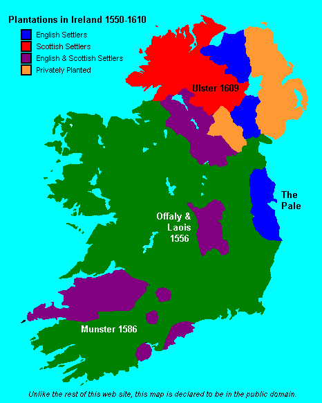
English: Map showing the major British crown-organised and private-sector "plantations" (colonies) in Ireland from ca. 1550 to 1610. Colour-coded as to Scottish, English or a mixture (other than it is not clear that the privately organized plantations in Ulster varied in composition, but heavy toward the Scots side). This file is supplied as requested PNG replacement for an undesirable GIF, though the entire thing would be better redone as an SVG. |
| Дата | (original 2007-05-09) |
| Источник | Proximally, from GIF version; ultimately, from http://www.wesleyjohnston.com/users/ireland/maps/historical/map1609.gif |
| Автор | www.wesleyjohnston.com |
| Права (Повторное использование этого файла) |
Public domain by declaration of original creator (see notice at bottom of original GIF-format upload) |
| Другие версии |
|

Лицензирование
License declared by original uploader User:NielsF:
| Я, владелец авторских прав на это произведение, передаю его в общественное достояние. Это разрешение действует по всему миру. В некоторых странах это не может быть возможно юридически, в таком случае: Я даю право кому угодно использовать данное произведение в любых целях без каких-либо условий, за исключением таких условий, которые требуются по закону. |
История файла
Нажмите на дату/время, чтобы посмотреть файл, который был загружен в тот момент.
| Дата/время | Миниатюра | Размеры | Участник | Примечание | |
|---|---|---|---|---|---|
| текущий | 17:04, 8 июня 2024 | | 466 × 565 (7 КБ) | SMcCandlish | {{Information |Description={{en|Map showing the major British crown-organised and private-sector "plantations" (colonies) in Ireland from ca. 1550 to 1610. Colour-coded as to Scottish, English or a mixture (other than it is not clear that the privately organized plantation varied in composition; the one in Ulster predominantly Scots settlers, the more southerly ones predominantly English). This file is supplied as requested PNG replacement for an undesirable GIF, though the entire thing would... |
Использование файла
Следующая страница использует этот файл:
Глобальное использование файла
Данный файл используется в следующих вики:
- Использование в ar.wikipedia.org
- Использование в da.wikipedia.org
- Использование в de.wikipedia.org
- Использование в en.wikipedia.org
- Использование в nl.wikipedia.org
- Использование в simple.wikipedia.org