Файл:North West England counties 2009 map.svg
Перейти к навигации
Перейти к поиску

Размер этого PNG-превью для исходного SVG-файла: 300 × 599 пкс. Другие разрешения: 120 × 240 пкс | 240 × 480 пкс | 385 × 768 пкс | 513 × 1024 пкс | 1026 × 2048 пкс | 674 × 1345 пкс.
Исходный файл (SVG-файл, номинально 674 × 1345 пкс, размер файла: 1,39 Мб)
Этот файл находится на Викискладе. Сведения о нём показаны ниже.
Викисклад — централизованное хранилище для свободных файлов, используемых в проектах Викимедиа.
|
Краткое описание
| Описание |
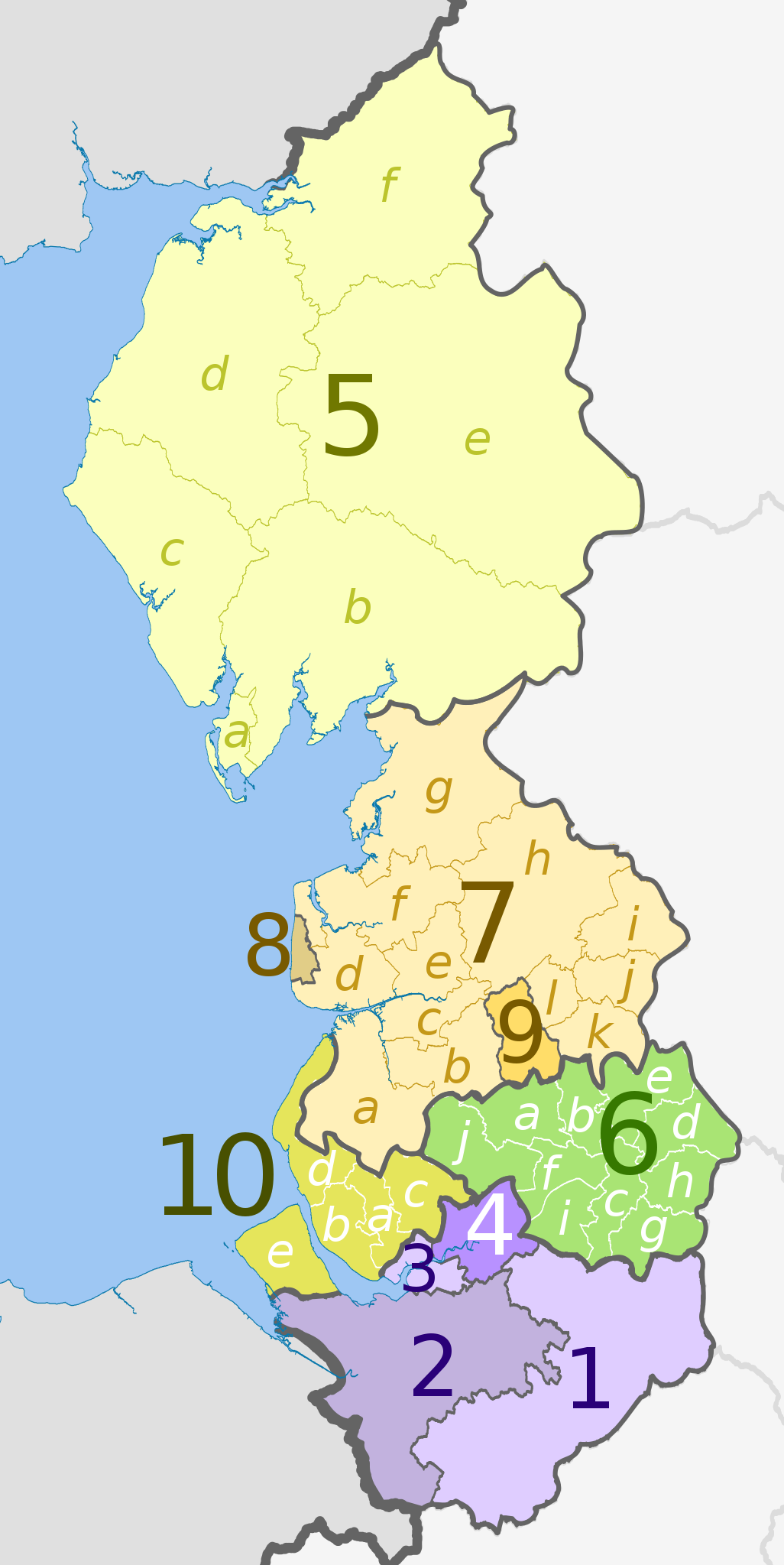
English: Map of the North West England region, showing its counties and administrative districts until 31 March 2023. The county colours are the same as those in File:English metropolitan and non-metropolitan counties 2009.svg.
For counties since 1 April 2023, see File:North West England counties 2023 map.svg. Equirectangular map projection on WGS 84 datum, with N/S stretched 170% Geographic limits:
|
| Дата | (UTC) |
| Источник |
Этот файл является производной работой от: |
| Автор |
|
| Другие версии | File:North West England counties 2023 map.svg – version since 1 April 2023 |


| Map | Ceremonial county | County/Unitary | Metropolitan/non-metropolitan districts |
|---|---|---|---|
 |
Cheshire | 1. Cheshire East U.A. | |
| 2. Cheshire West and Chester U.A. | |||
| 3. Halton U.A. | |||
| 4. Warrington U.A. | |||
| 5. Cumbria † | a) Barrow-in-Furness, b) South Lakeland, c) Copeland, d) Allerdale, e) Eden, f) Carlisle | ||
| 6. Greater Manchester * | a) Bolton, b) Bury, c) Manchester, d) Oldham, e) Rochdale, f) Salford, g) Stockport, h) Tameside, i) Trafford, j) Wigan | ||
| Lancashire | 7. Lancashire † | a) West Lancashire, b) Chorley, c) South Ribble, d) Fylde, e) Preston, f) Wyre, g) Lancaster, h) Ribble Valley, i) Pendle, j) Burnley, k) Rossendale, l) Hyndburn | |
| 8. Blackpool U.A. | |||
| 9. Blackburn with Darwen U.A. | |||
| 10. Merseyside * | a) Knowsley, b) Liverpool, c) St. Helens, d) Sefton, e) Wirral | ||
Key: †shire county | *metropolitan county
Лицензирование
Этот файл доступен по лицензии Creative Commons Attribution-Share Alike 3.0 Unported.
Атрибуция: Dr Greg and Nilfanion. Contains Ordnance Survey data © Crown copyright and database right 2011
- Вы можете свободно:
- делиться произведением – копировать, распространять и передавать данное произведение
- создавать производные – переделывать данное произведение
- При соблюдении следующих условий:
- атрибуция – Вы должны указать авторство, предоставить ссылку на лицензию и указать, внёс ли автор какие-либо изменения. Это можно сделать любым разумным способом, но не создавая впечатление, что лицензиат поддерживает вас или использование вами данного произведения.
- распространение на тех же условиях – Если вы изменяете, преобразуете или создаёте иное произведение на основе данного, то обязаны использовать лицензию исходного произведения или лицензию, совместимую с исходной.
Исходный журнал загрузок
This image is a derivative work of the following images:
- File:North_West_England_districts_2011_map.svg licensed with Cc-by-sa-3.0, GFDL
- 2011-05-01T19:03:10Z Nilfanion 674x1345 (1403071 Bytes) == Summary == {{Information |Description=Map of the [[w:North West England|North West England]] region showing the administrative districts. Equirectangular map projection on WGS 84 datum, with N/S stretched 170% Geographic
- File:English_ceremonial_counties_2010.svg licensed with Cc-by-sa-3.0, GFDL
- 2010-11-23T16:39:55Z Nilfanion 1108x1345 (308868 Bytes) thicker lines
- 2010-11-23T16:20:19Z Nilfanion 1108x1345 (301520 Bytes) tweaks
- 2010-10-26T20:34:20Z Nilfanion 817x990 (1391832 Bytes) {{Information |Description=Map showing the [[w:ceremonial counties of England]] including the City of London, in 2010. Equirectangular map projection on WGS 84 datum, with N/S stretched 170% Geographic limits: *West: 6.75W
Uploaded with derivativeFX
История файла
Нажмите на дату/время, чтобы посмотреть файл, который был загружен в тот момент.
| Дата/время | Миниатюра | Размеры | Участник | Примечание | |
|---|---|---|---|---|---|
| текущий | 20:08, 5 мая 2012 | | 674 × 1345 (1,39 Мб) | Dr Greg | lighten black boundary line |
| 23:16, 1 мая 2012 |  | 674 × 1345 (1,39 Мб) | Dr Greg | == {{int:filedesc}} == {{Information |Description={{en|Map of the North West England region, showing its counties and administrative districts. The county colours are the same as those in [[:File:English metropolitan and non-me... |
Использование файла
Следующая страница использует этот файл:
Глобальное использование файла
Данный файл используется в следующих вики:
- Использование в ar.wikipedia.org
- Использование в fa.wikipedia.org
- Использование в frr.wikipedia.org
- Использование в hr.wikipedia.org
- Использование в hu.wikipedia.org
- Использование в mr.wikipedia.org
- Использование в no.wikipedia.org
- Использование в pl.wikipedia.org
- Использование в pnb.wikipedia.org
- Использование в pt.wikipedia.org
- Использование в sh.wikipedia.org
- Использование в th.wikipedia.org
- Использование в ur.wikipedia.org
- Использование в vi.wikipedia.org
- Использование в vls.wikipedia.org
- Использование в zh-yue.wikipedia.org