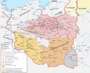
Файл:Panstwo mieclawa.svg
Перейти к навигации
Перейти к поиску

Размер этого PNG-превью для исходного SVG-файла: 700 × 567 пкс. Другие разрешения: 296 × 240 пкс | 593 × 480 пкс | 948 × 768 пкс | 1264 × 1024 пкс | 2529 × 2048 пкс.
Исходный файл (SVG-файл, номинально 700 × 567 пкс, размер файла: 3,21 МБ)
История файла
Нажмите на дату/время, чтобы посмотреть файл, который был загружен в тот момент.
| Дата/время | Миниатюра | Размеры | Участник | Примечание | |
|---|---|---|---|---|---|
| текущий | 17:31, 28 июня 2024 |  | 700 × 567 (3,21 МБ) | Bornholm | Reverted to version as of 17:24, 7 February 2024 (UTC) The Yotvingians did not live further south than the course of the Narew rivers. This is confirmed archaeologically. There are also no reliable historical sources that confirm settlements south of this river. South of this river there are no traces of their settlement or other Baltic tribes. Invasions to the south were only robbery and never had a settlement character. |
| 18:32, 11 февраля 2024 |  | 700 × 567 (3,3 МБ) | +JMJ+ | Reverted to version as of 21:38, 18 December 2023 (UTC) - "jotvingiai iki 12–13 a. pietuose gyvenę iki Bugo upės (Brastos-Drohičino apylinkėse)" (https://www.vle.lt/straipsnis/jotvingiai/). "until the 12th-13th centuries, Yotvingians lived in the south up to the Bug river (in the vicinity of Lithuanian Brest-Drohiczyn)". Yotvingian borders are ahistorically minimalized in this map and inaccurately depicted as part of Poland despite that not being the case. | |
| 17:24, 7 февраля 2024 |  | 700 × 567 (3,21 МБ) | Bornholm | Reverted to version as of 21:43, 25 November 2023 (UTC) The Yotvingians did not live further south than the course of the Narew rivers. This is confirmed archaeologically. There are also no reliable historical sources that confirm settlements south of this river. South of this river there are no traces of their settlement or other Baltic tribes. Invasions to the south were only robbery and never had a settlement character. | |
| 21:38, 18 декабря 2023 |  | 700 × 567 (3,3 МБ) | +JMJ+ | Reverted to version as of 16:12, 28 August 2023 (UTC) - revert to historically accurate version | |
| 21:43, 25 ноября 2023 |  | 700 × 567 (3,21 МБ) | Kamilhrub | Reverted to version as of 10:48, 22 May 2023 (UTC) as in book source | |
| 16:12, 28 августа 2023 |  | 700 × 567 (3,3 МБ) | +JMJ+ | Reverted to version as of 10:07, 16 May 2023 (UTC) - https://www.vle.lt/straipsnis/jotvingiai/ says that "the Jotvingians lived in the south up to the Bug river (in the vicinity of Brasta-Drohičin) until the 12th-13th century." | |
| 10:48, 22 мая 2023 |  | 700 × 567 (3,21 МБ) | Bornholm | Reverted to version as of 14:43, 27 March 2023 (UTC) The Yotvingians did not live further south than the course of the Narew rivers. This is confirmed archaeologically. There are also no reliable historical sources that confirm settlements south of this river. South of this river there are no traces of their settlement or other Baltic tribes. Invasions to the south were only robbery and never had a settlement character. | |
| 10:07, 16 мая 2023 |  | 700 × 567 (3,3 МБ) | +JMJ+ | Reverted to version as of 07:52, 25 February 2023 (UTC) Yotvingians were indeed inhabiting that far south - they were fighting for their native lands there against various Slavs (including the Poles) still in the 12th century | |
| 14:43, 27 марта 2023 |  | 700 × 567 (3,21 МБ) | Bornholm | Correction of the Polish border with Yotvingians. Yotvingian tribes never had settlements so far south and never reached the Bug river. | |
| 07:52, 25 февраля 2023 |  | 700 × 567 (3,3 МБ) | ZxcvU | Przemysl was under Kyivan Rus' control since Yaroslav's March on Poland in 1031 |
Использование файла
Следующие 2 страницы используют этот файл:
Глобальное использование файла
Данный файл используется в следующих вики:
- Использование в de.wikipedia.org
- Использование в en.wikipedia.org
- Использование в ja.wikipedia.org
- Использование в pl.wikipedia.org
- Использование в sl.wikipedia.org
- Использование в sv.wikipedia.org
- Использование в uk.wikipedia.org
- Использование в www.wikidata.org
