Файл:Titan 2009-01 ISS polar maps.jpg
Исходный файл (1884 × 942 пкс, размер файла: 510 Кб, MIME-тип: image/jpeg)
Этот файл находится на Викискладе. Сведения о нём показаны ниже.
Викисклад — централизованное хранилище для свободных файлов, используемых в проектах Викимедиа.
|
Краткое описание
| Описание |
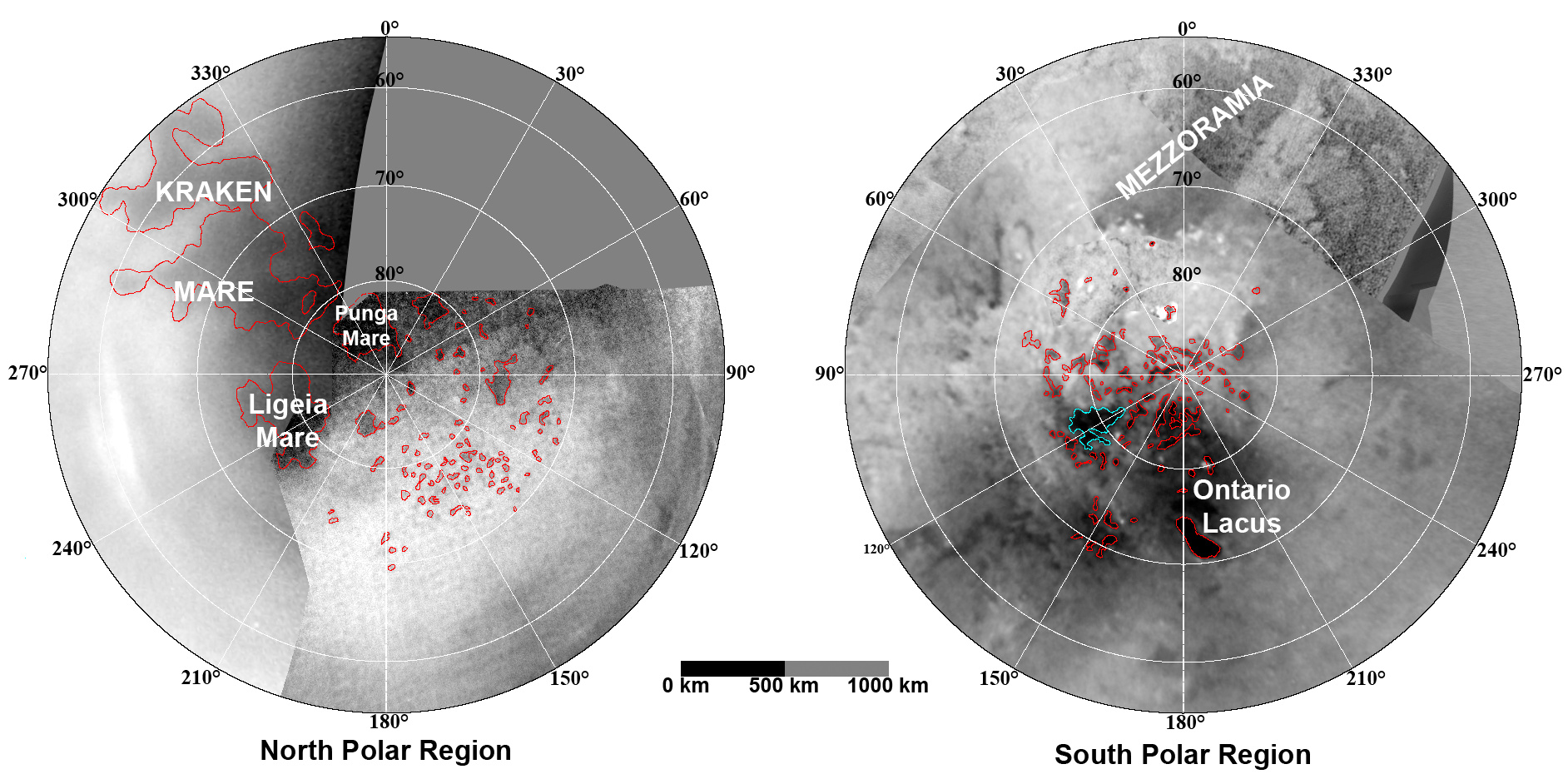
English: These updated maps of Saturn’s moon Titan, consisting of data from the Cassini Imaging Science Subsystem, include Cassini's August 2008 images of the moon's north polar region.
Evidence from Cassini's Imaging Science Subsystem, RADAR, and Visual and Infrared Mapping Spectrometer instruments strongly suggests that dark areas near the poles are lakes of liquid hydrocarbons like ethane or methane -- an analysis affirmed by images capturing changes in the lakes thought to be brought on by rainfall. Colored lines in the polar portions of these maps illustrate the boundaries between surface regions having different albedos -- or differences in surface brightness -- which Cassini scientists have interpreted as potential shorelines. Blue outlines indicate features that changed between observations made one year apart (see PIA11147). The map at left is a north polar projection showing latitudes 55 degrees to 90 degrees. The right map is a south polar projection showing latitudes minus qq55 degrees to minus 90 degrees. The maps are compiled from images dating from April 2004 through August 2008, and their resolutions vary from several hundred meters to a few tens of kilometers. Brightness variations are due to differences in surface albedo rather than topographic shading. The original NASA map of Titan has been cropped to show only the polar regions.Deutsch: Oberflächenkarte der beiden Pole, erstellt aus Daten des Cassini Imaging Science Subsystems, Januar 2009. |
| Дата | |
| Источник | File:TitanMapJan2009.jpg, http://photojournal.jpl.nasa.gov/catalog/PIA11146 |
| Автор | NASA/JPL/Space Science Institute |
| Другие версии |
http://photojournal.jpl.nasa.gov/catalog/PIA11146
|

Лицензирование
Это произведение находится в общественном достоянии, поскольку содержит материалы Национального управления океанических и атмосферных исследований США, полученные его сотрудниками в ходе выполнения должностных обязанностей.
|
История файла
Нажмите на дату/время, чтобы посмотреть файл, который был загружен в тот момент.
| Дата/время | Миниатюра | Размеры | Участник | Примечание | |
|---|---|---|---|---|---|
| текущий | 23:26, 7 августа 2010 | | 1884 × 942 (510 Кб) | LobStoR | improved quality |
| 11:26, 31 января 2009 |  | 1884 × 944 (499 Кб) | WolfmanSF | {{Information |Description={{en|1=These updated maps of Saturn’s moon Titan, consisting of data from the Cassini Imaging Science Subsystem, include Cassini's August 2008 images of the moon's north polar region. Evidence from Cassini's Imaging Science S |
Использование файла
Следующая страница использует этот файл:
Глобальное использование файла
Данный файл используется в следующих вики:
- Использование в an.wikipedia.org
- Использование в ar.wikipedia.org
- Использование в be.wikipedia.org
- Использование в de.wikipedia.org
- Использование в en.wikipedia.org
- Использование в en.wikiversity.org
- Использование в fr.wikipedia.org
- Использование в hy.wikipedia.org
- Использование в id.wikipedia.org
- Использование в ja.wikipedia.org
- Использование в lb.wikipedia.org
- Использование в mk.wikipedia.org
- Использование в no.wikipedia.org
- Использование в ro.wikipedia.org
- Использование в uk.wikipedia.org
- Использование в vi.wikipedia.org
- Использование в zh.wikipedia.org