Файл:Whitsunday Islands, Queensland, Australia.jpg
Перейти к навигации
Перейти к поиску

Размер этого предпросмотра: 480 × 600 пкс. Другие разрешения: 192 × 240 пкс | 384 × 480 пкс | 614 × 768 пкс | 819 × 1024 пкс | 1638 × 2048 пкс | 4000 × 5000 пкс.
Исходный файл (4000 × 5000 пкс, размер файла: 3,43 МБ, MIME-тип: image/jpeg)
Этот файл находится на Викискладе. Сведения о нём показаны ниже.
Викисклад — централизованное хранилище для свободных файлов, используемых в проектах Викимедиа.
|
Краткое описание
| Описание |
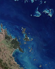
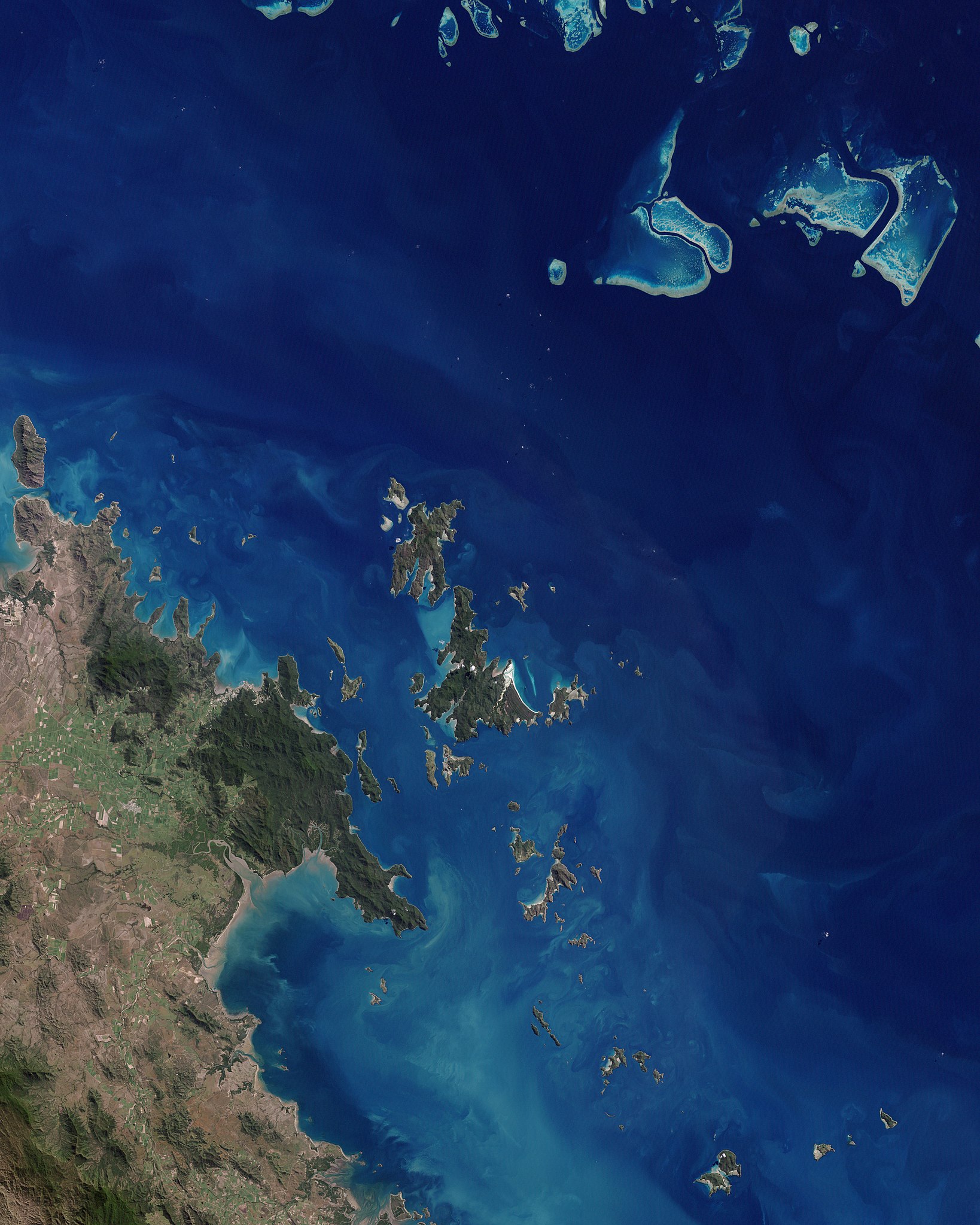
English: This scene is dominated by the largest island and namesake of the chain. Deep green forest covers most of Whitsunday Island, which is outlined by brilliant white sand beaches, the largest and most dramatic being Whitehaven Beach at the south-eastern end of the island. On Hamilton Island, the strong linear feature at the southern end shows where a jet-accessible runway was added to allow airlines from major Australian cities to fly directly to the islands. The swirls of pale blue around the islands show a mix of sandy bottom waters and shallow, fringing coral reefs. The green land in the south-western corner of the image is a small section of Conway Ranges National Park, on the shoreline of mainland Queensland.
Deutsch: Dieses photoähnliche Bild des Kerns der Whitsunday Islands wurde am 22. Mai 2003 mit dem Enhanced Thematic Mapper Plus (ETM+) des Landsat 7 erstellt. Das Bild wird von der größten Insel und Namensgeberin für die gesamte Inselgruppe dominiert. Den größtem Teil der Whitsunday Island bedecken tiefgrüne Wälder, die von brillanten weißen Sandstränden eingerahmt werden – der größte unter ihnen ist Whitehaven Beach im Südosten der Insel. |
| Дата | |
| Источник | NASA Earth Observatory |
| Автор | Jesse Allen |
| Другие версии | File:Whitsunday Islands Landsat 7 with some captions.jpg |
Image acquired by the Enhanced Thematic Mapper Plus (ETM+) instrument on NASA’s Landsat 7 satellite. Landsat data provided by the United States Geological Survey.
Лицензирование
| Этот файл находится в общественном достоянии (англ. public domain), так как он был создан NASA (Национальным управлением по аэронавтике и исследованию космического пространства). Политика авторского права NASA гласит, что «Материал NASA не защищается авторским правом, если не указано иное». (См. Template:PD-USGov, страницу политики авторского права NASA или политику использования изображений JPL.) | ||
 |
Предупреждения:
|
| Аннотации | Это изображение аннотировано: Просмотреть аннотации на Викискладе |
История файла
Нажмите на дату/время, чтобы посмотреть файл, который был загружен в тот момент.
| Дата/время | Миниатюра | Размеры | Участник | Примечание | |
|---|---|---|---|---|---|
| текущий | 12:26, 7 января 2010 | | 4000 × 5000 (3,43 МБ) | Originalwana | {{Information |Description={{en|1=This scene is dominated by the largest island and namesake of the chain. Deep green forest covers most of Whitsunday Island, which is outlined by brilliant white sand beaches, the largest and most dramatic being Whitehave |
Использование файла
Следующая страница использует этот файл:
Глобальное использование файла
Данный файл используется в следующих вики:
- Использование в af.wikipedia.org
- Использование в be.wikipedia.org
- Использование в en.wikipedia.org
- Использование в eo.wikipedia.org
- Использование в it.wikipedia.org
- Использование в mr.wikipedia.org
- Использование в nl.wikipedia.org
- Использование в pl.wikipedia.org
- Использование в zh.wikipedia.org