Файл:Montenegro Map.png

Исходный файл (2427 × 1807 пкс, размер файла: 1,03 Мб, MIME-тип: image/png)
Этот файл находится на Викискладе. Сведения о нём показаны ниже.
Викисклад — централизованное хранилище для свободных файлов, используемых в проектах Викимедиа.
|
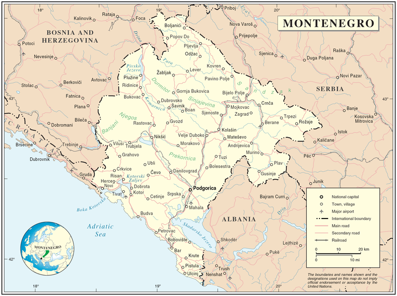
Map of Montenegro
| Описание | Map of Montenegro | |||
| Дата | ||||
| Источник | The Cartographic Section of the United Nations (CSUN) | |||
| Автор | Cartographer of the United Nations | |||
| Права (Повторное использование этого файла) |
|

История файла
Нажмите на дату/время, чтобы посмотреть файл, который был загружен в тот момент.
| Дата/время | Миниатюра | Размеры | Участник | Примечание | |
|---|---|---|---|---|---|
| текущий | 17:03, 10 марта 2007 | | 2427 × 1807 (1,03 Мб) | Minestrone | Map of Montenegro {{Information |Description=Map of Montenegro |Source=The Cartographic Section of the United Nations (CSUN) |Date=2007-03-10 |Author=Cartographer of the United Nations |Permission={{Template:UN map}} and the cartographer of the UN [ |
Использование файла
Следующие 2 страницы используют этот файл:
Глобальное использование файла
Данный файл используется в следующих вики:
- Использование в als.wikipedia.org
- Использование в ar.wikipedia.org
- Использование в avk.wikipedia.org
- Использование в be-tarask.wikipedia.org
- Использование в bg.wikipedia.org
- Использование в cs.wikipedia.org
- Использование в cy.wikipedia.org
- Использование в de.wikipedia.org
- Использование в el.wikipedia.org
- Использование в en.wikipedia.org
- Использование в fa.wikipedia.org
- Использование в fr.wikipedia.org
- Использование в gag.wikipedia.org
- Использование в gd.wikipedia.org
- Использование в hr.wiktionary.org
- Использование в ia.wikipedia.org
- Использование в incubator.wikimedia.org
- Использование в io.wikipedia.org
- Использование в ka.wikipedia.org
- Использование в la.wikipedia.org
- Использование в ms.wikipedia.org
- Использование в nl.wikipedia.org
- Использование в pl.wikipedia.org
- Использование в pl.wiktionary.org
- Использование в pnb.wikipedia.org
- Использование в ps.wikipedia.org
- Использование в rm.wikipedia.org
- Использование в roa-tara.wikipedia.org
- Использование в ro.wikipedia.org
- Использование в ro.wikivoyage.org
- Использование в sl.wikipedia.org
Просмотреть глобальное использование этого файла.