Файл:Swisstopo Dufourkarte BLATT VII. PORRENTRUY SOLOTHURN LT TK 007 1845.tiff

Исходный файл (11 680 × 8600 пкс, размер файла: 95,82 МБ, MIME-тип: image/tiff)
Этот файл находится на Викискладе. Сведения о нём показаны ниже.
Викисклад — централизованное хранилище для свободных файлов, используемых в проектах Викимедиа.
|
Краткое описание
| Название |
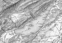
Deutsch: Blatt VII. Porrentruy, Solothurn der Topographischen Karte der Schweiz, LT TK 007 1845 |
|||||||||||||||||||||||
| Описание |
English: Sheet VII. Porrentruy, Solothurn of Topographische Karte der Schweiz (Dufour Map).
Deutsch: Blatt VII. Porrentruy, Solothurn der Topographischen Karte der Schweiz, auch Dufourkarte genannt. Dieses älteste amtliche Kartenwerk der Schweiz wurde unter der Leitung von Guillaume Henri Dufour erstellt.
Français : Feuille VII. Porrentruy, Solothurn de la Carte Dufour. |
|||||||||||||||||||||||
| Map legend |
Deutsch: Zeichen und Abkürzungen |
|||||||||||||||||||||||
| Adjacent sheets |
|
|||||||||||||||||||||||
| Sheet index | index map, gallery | |||||||||||||||||||||||
| Источник |
|
|||||||||||||||||||||||
| Создатель | ||||||||||||||||||||||||
| Права (Повторное использование этого файла) |
|
|||||||||||||||||||||||
| Geotemporal data | ||||||||||||||||||||||||
| Изображённое время | ||||||||||||||||||||||||
| Map location | Porrentruy, Solothurn | |||||||||||||||||||||||
| Система пространственной привязки | Bonne'sche Projektion | |||||||||||||||||||||||
| Масштаб | 1:100 000 | |||||||||||||||||||||||
| Heading |
 |
|||||||||||||||||||||||
| Georeferencing | If inappropriate please set warp_status = skip to hide. | |||||||||||||||||||||||
| Bibliographic data | ||||||||||||||||||||||||
| Является частью цикла | Erstausgabe Topographische Karte der Schweiz | |||||||||||||||||||||||
| Map sheet | 7 | |||||||||||||||||||||||
| Язык | немецкий | |||||||||||||||||||||||
| Издательство | ||||||||||||||||||||||||
| Archival data | ||||||||||||||||||||||||
| Коллекция |
Bundesamt für Landestopografie swisstopo, Kartensammlung
|
|||||||||||||||||||||||
| Инвентарный номер |
LT TK 007 1845 |
|||||||||||||||||||||||
| Размеры | высота: 61 см; ширина: 83 см | |||||||||||||||||||||||

Лицензирование
The data made publicly available by swisstopo may be used, distributed and made accessible. Furthermore, they may be enriched and processed and also used commercially. A reference to the source is mandatory. In the case of digital or analogue representations and publications, as well as in the case of dissemination, one of the following source references must be attached in any case:
Terms of use for free geodata and geoservices (OGD) from swisstopo
|
.svg) |
История файла
Нажмите на дату/время, чтобы посмотреть файл, который был загружен в тот момент.
| Дата/время | Миниатюра | Размеры | Участник | Примечание | |
|---|---|---|---|---|---|
| текущий | 15:07, 13 июня 2023 |  | 11 680 × 8600 (95,82 МБ) | Swisstopo historic | {{Map |title=Blatt VII. Porrentruy, Solothurn der Topographischen Karte der Schweiz, LK TK 007 1845 |description=Blatt VII. Porrentruy, Solothurn der Topographischen Karte der Schweiz, auch Dufourkarte genannt. Dieses älteste amtliche Kartenwerk der Schweiz wurde unter der Leitung von Guillaume Henri Dufour erstellt. {{Cultural property of regional significance in Switzerland|996}} |author=Guillaume-Henri Dufour; Rinaldo Bressanini; Heinrich Müllhaupt; [[Eidgenössisches Topographi... |
Использование файла
Нет страниц, использующих этот файл.
Глобальное использование файла
Данный файл используется в следующих вики:
- Использование в de.wikipedia.org