Файл:Wfm shetland map.svg

Исходный файл (SVG-файл, номинально 1077 × 1413 пкс, размер файла: 426 КБ)
Этот файл находится на Викискладе. Сведения о нём показаны ниже.
Викисклад — централизованное хранилище для свободных файлов, используемых в проектах Викимедиа.
|
Краткое описание
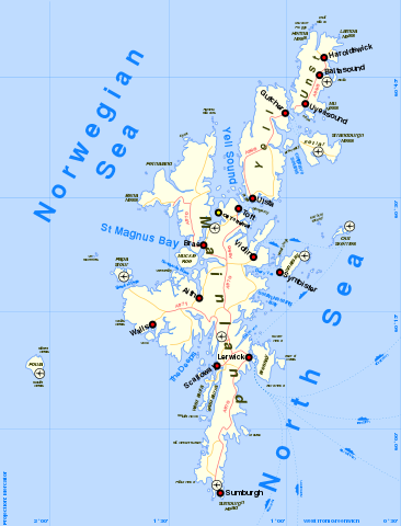
| Описание | Map of Shetland Islands in Scotland (The original SVG sources for Image:Wfm shetland map.png) |
| Дата | |
| Источник | self-made, details of process below (original geo-data from public domain sources) |
| Автор | Finlay McWalter |
| Права (Повторное использование этого файла) |
I'm Finlay McWalter, and I endorse this message |
| Другие версии | Image:Wfm shetland map.png |
Method of production
Drawn by Finlay McWalter in the following manner:
- An outline was rendered using Panmap running public domain NOAA WVS (world vector shoreline).
- This was exported (as a bitmap, all that Panmap can do) to Paint Shop Pro. This was manually repaired (holes filled, island groups tweaked, and shoreline details clarified or erased). Then the bitmap was floodfilled, so that the subsequent vectoriser will produce polygons rather than lines.
- This was imported into Inkscape and vectorised using Inkscape's "path->trace bitmap" function.
- All details were then manually drawn.
- (for the PNG file) To produce the final PNG, the whole drawing was exported from Inkscape as a PNG. This was then cropped in Photoshop.
Notes on the SVG file (for editors/translators)
- The SVG file contains some housekeeping entities beyond the margin - MediaWiki ignores these when rendering for the screen, so I suggest we leave these in, as they're handy reminders of things.
- The file was created in Inkscape, and I strongly suggest others edit it in Inkscape (I don't know how other SVG editors handle the layer information Inkscape keeps in the document - layers are really vital to handling a drawing this complex)
- Different features in the drawing use different layers, with hopefully sensible names (in descending Z-order):
- towns - the roundels for towns, their names, and for airport
- land text - the black text naming islands and other land features
- main roads - red A-grade roads and their red texts
- minor roads - yellow B-grade (or lower) roads and their yellow texts
- sea text - dark blue text naming seas and larger bodies of water
- swatches - some housekeeping text off the page
- sea text (detailed) - dark blue text naming a few (3 or so) important but smaller bodies of water.
- land - the cream-coloured land itself (but not the bluey outline)
- sealanes - dark blue dashed lines showing ferry routes, and the ferry icons and names of destinations (notes: 1. this was correct as of 2005, it may require updating; 2. if you need to add more routes, or move existing ones, remember that getting the dashes to line up south of Lerwick harbour is important, and rather hard)
- land glow - the bluesh ring around all the islands. If you need to change the land form, I'd advise you zap this object and make a fresh one from the land with path->outset (and then put that back into this layer with the appropriate colour). [SVG has some later features which might automate this?]
- latlong - dark blue lines of latitude and longitude, associated numbers, and the text "west of greenwich" and "projection:mercator" [For a more detailed map you might consider adding a latlong-detailed layer with lines closer together
- sea - the light blue rectangle of the sea, which (exactly) fills the page
- When editing the map I very strongly recommend you keep all the layers locked and edit only one at a time - it's really easy to mess things up otherwise.
- There is a bug in the SVG renderer used by mediawiki: when asked to render text with multiple adjacent spaces between letters, it elides this down as if there were only one space. This causes a problem for atlas text where one stretches names out over landmasses with several spaces between letters (the renderers used by Inkscape and Firefox3 don't have this error). To fix this I've pasted in nonbreaking space character entities to pad out the letters in "mainland", "unst", and "yell". Really something similar should be done for "north sea" and "norwegian sea"
- There's a bug in the renderer which means it misrenders text placed on a curve. In the SVG original (as rendered in Inkscape and Firefox3) you'll see the text "Sullom Voe" rendered in the Voe itself (carefully bent around to fill up the water nicely. The bug in the renderer makes this invisible (it should be possible to have Inkscape render this straight into a path, but should we really be hacking our images to work around such bugs?)
The past and future of this map
This map was drawn in 2005 by me (en:user:Finlay McWalter) for the English Wikipedia. Due to the poor performance of Inkscape at that time (which bogged-down heavily when viewing complex polylines up close) I mostly gave up on improving this map. In 2008 en:user:Piisamson, noting that the map was in use on other wikis, asked for me to upload the SVG version - I'm happy to oblige. I don't have much time for Wikipedia any more, so it's unlikely that I'll be making further improvements on this map, but I do hope it's of use. If I might, here are some suggestions:
- translations should now be straightforward
- producing simplified maps locating specific islands (which is why Piisamson asked, I believe) should also be straightforward
- I've deliberately put things into layers, and it's easy to delete a layer and produce a map for other purposes. These islands have a rich history, and I'd imagine there would be some mileage in removing the towns and roads layers and adding an historic-settlements or castles or battles layer
- Due to the way the map was made, there is a tendency for neighbouring islands to be smushed together - particularly when creating zoomed-in local maps, I'd strongly suggest checking the coast against a more detailed map and fixing any such elisions.
Version history
PNG version:
- (July 14th 2005) Initial test version
- (August 29th 2005) Added towns, airports, oil terminal. Muckle Roe now correctly rendered as a separate island.
- (August 29th 2005) Swapped locations of Sumburgh town and Sumburgh Airport, PNGcrushed image.
SVG upload:
- (June 25th 2008) Uploaded original SVG with changes to support use on MediaWiki svg renderer (changed fonts from "Trebuchet MS" to "Nimbus Sans L" <Note this corresponds with original author's personal version #8>
- (June 25th 2008) Fixed "mainland" text - MediaWiki's renderer can't handle text-on-paths <Note this corresponds with original author's personal version #9>
See also
There's also a similar, but incomplete, map of Orkney at Image:Wfm orkney map.svg
Лицензирование

|
Разрешается копировать, распространять и/или изменять этот документ в соответствии с условиями GNU Free Documentation License версии 1.2 или более поздней, опубликованной Фондом свободного программного обеспечения, без неизменяемых разделов, без текстов, помещаемых на первой и последней обложке. Копия лицензии включена в раздел, озаглавленный GNU Free Documentation License. |
- Вы можете свободно:
- делиться произведением – копировать, распространять и передавать данное произведение
- создавать производные – переделывать данное произведение
- При соблюдении следующих условий:
- атрибуция – Вы должны указать авторство, предоставить ссылку на лицензию и указать, внёс ли автор какие-либо изменения. Это можно сделать любым разумным способом, но не создавая впечатление, что лицензиат поддерживает вас или использование вами данного произведения.
- распространение на тех же условиях – Если вы изменяете, преобразуете или создаёте иное произведение на основе данного, то обязаны использовать лицензию исходного произведения или лицензию, совместимую с исходной.
История файла
Нажмите на дату/время, чтобы посмотреть файл, который был загружен в тот момент.
| Дата/время | Миниатюра | Размеры | Участник | Примечание | |
|---|---|---|---|---|---|
| текущий | 18:36, 26 июня 2008 | | 1077 × 1413 (426 КБ) | Finlay McWalter | Replace spaces within "Yell" and "Unst" labels with nonbreaking space characters |
| 18:21, 26 июня 2008 |  | 1077 × 1413 (426 КБ) | Finlay McWalter | experiment: replacing adjacent spaces in "mainland" text with nonblocking space entities, to overcome MediaWikiSVG bug | |
| 22:19, 25 июня 2008 |  | 1077 × 1413 (426 КБ) | Finlay McWalter | tidied road vectors and fixed road junction alignment (my v10) | |
| 18:14, 25 июня 2008 |  | 1077 × 1413 (427 КБ) | Finlay McWalter | ||
| 18:04, 25 июня 2008 |  | 1077 × 1413 (427 КБ) | Finlay McWalter | {{Information |Description={{en|1=== Summary == {{Information| |Description = Shetland map |Source = self-made, details of process below |Date = 29th August 2005 |Author = Finlay McWalter |Permission = I'm Fi |
Использование файла
Следующие 2 страницы используют этот файл:
Глобальное использование файла
Данный файл используется в следующих вики:
- Использование в af.wikipedia.org
- Использование в ca.wikipedia.org
- Использование в da.wikipedia.org
- Использование в de.wikipedia.org
- Использование в dsb.wikipedia.org
- Использование в el.wikipedia.org
- Использование в en.wikipedia.org
- Использование в es.wikipedia.org
- Использование в fi.wikipedia.org
- Использование в fr.wikipedia.org
- Использование в fy.wikipedia.org
- Использование в hr.wikipedia.org
- Использование в hu.wikipedia.org
- Использование в id.wikipedia.org
- Использование в incubator.wikimedia.org
- Использование в it.wikipedia.org
- Использование в ja.wikipedia.org
- Использование в nl.wikipedia.org
- Использование в nn.wikipedia.org
- Использование в pt.wikipedia.org
- Использование в qu.wikipedia.org
- Использование в simple.wikipedia.org
- Использование в sl.wikipedia.org
- Использование в sv.wikipedia.org
- Использование в sw.wikipedia.org
Просмотреть глобальное использование этого файла.