Файл:Katmai National Park Geologic Map.png
Перейти к навигации
Перейти к поиску

Размер этого предпросмотра: 800 × 331 пкс. Другие разрешения: 320 × 132 пкс | 640 × 265 пкс | 1829 × 756 пкс.
Исходный файл (1829 × 756 пкс, размер файла: 1,9 МБ, MIME-тип: image/png)
Этот файл находится на Викискладе. Сведения о нём показаны ниже.
Викисклад — централизованное хранилище для свободных файлов, используемых в проектах Викимедиа.
|
Краткое описание
| Описание |
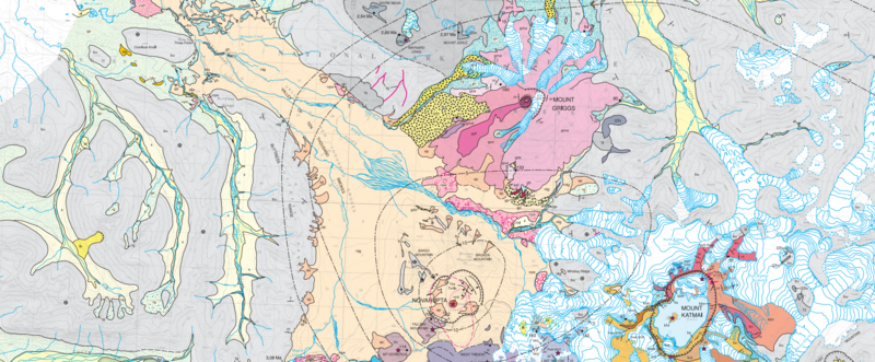
English: Katmai National Park Geologic Map, where nig is the Episode I valley-filling ignimbrite of 6-7 June 1912, bu is Late Jurassic Naknek Formation basement rock, nrd is the Novarupta rhyolite dome and ap its pumiceous alluvium, while ks, kbn and kn are Mount Katmai Late Pleistocene andesites and khi is the Horseshoe Island dacite. Mount Griggs' andesites are represented by gma, gyl and gyo, while gdo is the Knife Peak debris avalanche, and npe are phreatic explosion deposits. The Falling Mountain dacite dome is represented by tfc and glacial till deposits are represented by gh for Holocene and gp for Late Pleistocene. |
| Дата | |
| Источник | Geologic Map of the Katmai Cluster, Katmai National Park, Alaska, USGS Geologic Investigations Series I-2778 |
| Автор | Wes Hildreth and Judy Fierstein |
Лицензирование
Это произведение находится в общественном достоянии (англ. public domain) в Соединённых Штатах Америки, так как оно является работой, выполненной должностным лицом или наёмным сотрудником Федерального правительства США в качестве части служебных обязанностей этого лица. Правовой статус регламентируется в соответствии с разделом 17, главой 1, секцией 105 Кодекса Соединённых Штатов. См. Авторское право.
Обратите внимание: это относится только к оригинальным (первоначальным) произведениям Федерального правительства, а не к произведениям любого отдельного штата США, территории, содружества, округа, муниципалитета или любой другой территориальной единицы. Этот шаблон также не относится к дизайну почтовых марок, изданных Почтовой службой США с 1978 года. (См. § 313.6(C)(1) в Compendium of U.S. Copyright Office Practices). Это также не относится к определённым монетам США; см. Условия использования Монетного двора США.
|
 | |
| Этот файл был определён как свободный от известных ограничений авторского права, а также связанных и смежных прав. | ||
История файла
Нажмите на дату/время, чтобы посмотреть файл, который был загружен в тот момент.
| Дата/время | Миниатюра | Размеры | Участник | Примечание | |
|---|---|---|---|---|---|
| текущий | 17:22, 3 августа 2018 | | 1829 × 756 (1,9 МБ) | Pi3.124 | removed white space |
| 17:08, 3 августа 2018 |  | 1825 × 1023 (1,79 МБ) | Pi3.124 | User created page with UploadWizard |
Использование файла
Нет страниц, использующих этот файл.
Глобальное использование файла
Данный файл используется в следующих вики:
- Использование в en.wikipedia.org