Файл:Lake Huron bathymetry map.png
Исходный файл (936 × 1024 пкс, размер файла: 1,35 МБ, MIME-тип: image/png)
Этот файл находится на Викискладе. Сведения о нём показаны ниже.
Викисклад — централизованное хранилище для свободных файлов, используемых в проектах Викимедиа.
|
Краткое описание
| Описание |
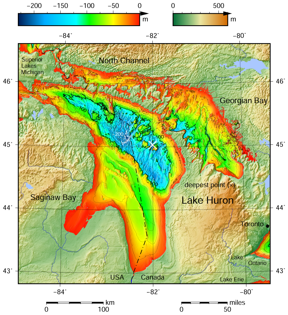
English: Lake Huron bathymetric shaded relief map contoured with interval 25 m (100 m with thicker lines). The deepest point is marked with "×". For land the vertical datum is sea level, for bathymetry low water datum of the lake. The map was created using the Generic Mapping Tools, GMT, version 5.1.1. |
| Дата | |
| Источник |
Собственная работа, используя: the following Public Domain datasets (grids):
The coordinates of deepest point are taken from the NOAA Great LakesEnvironmental Research Laboratory webpage (www.glerl.noaa.gov/, kml file Google Earth Great Lakes Tour). |
| Автор | Darekk2 using the Great Lakes Bathymetry and GLOBE tiles |
| Другие версии |
|

Лицензирование
Attribution (in addition to the author of this map):
The NGDC in it's copyright notice says:
As required by 17 U.S.C. 403, third parties producing copyrighted works consisting predominantly of the material produced by U.S. government agencies must provide notice with such work(s) identifying the U.S. Government material incorporated and stating that such material is not subject to copyright protection within the United States. (...)
(for credits see the Source section).
and Great Lakes Bathymetry and GLOBE
(see above and the Source section)
- Вы можете свободно:
- делиться произведением – копировать, распространять и передавать данное произведение
- создавать производные – переделывать данное произведение
- При соблюдении следующих условий:
- атрибуция – Вы должны указать авторство, предоставить ссылку на лицензию и указать, внёс ли автор какие-либо изменения. Это можно сделать любым разумным способом, но не создавая впечатление, что лицензиат поддерживает вас или использование вами данного произведения.
- распространение на тех же условиях – Если вы изменяете, преобразуете или создаёте иное произведение на основе данного, то обязаны использовать лицензию исходного произведения или лицензию, совместимую с исходной.
История файла
Нажмите на дату/время, чтобы посмотреть файл, который был загружен в тот момент.
| Дата/время | Миниатюра | Размеры | Участник | Примечание | |
|---|---|---|---|---|---|
| текущий | 12:21, 10 мая 2015 | | 936 × 1024 (1,35 МБ) | Darekk2 | a small island in NE Michigan |
| 18:00, 8 мая 2015 |  | 936 × 1024 (1,35 МБ) | Darekk2 | forgot about few islands in south ... !! | |
| 16:57, 8 мая 2015 |  | 936 × 1024 (1,35 МБ) | Darekk2 | thicker deepest point mark | |
| 15:27, 8 мая 2015 |  | 936 × 1024 (1,35 МБ) | Darekk2 | User created page with UploadWizard |
Использование файла
Нет страниц, использующих этот файл.
Глобальное использование файла
Данный файл используется в следующих вики:
- Использование в ban.wikipedia.org
- Использование в en.wikipedia.org
- Использование в id.wikipedia.org
- Использование в kn.wikipedia.org
- Использование в th.wikipedia.org
- Использование в vi.wikipedia.org
- Использование в www.wikidata.org