Файл:Russian wildfires ESA377800.tiff

Исходный файл (9438 × 10 000 пкс, размер файла: 540,07 Мб, MIME-тип: image/tiff)
Этот файл находится на Викискладе. Сведения о нём показаны ниже.
Викисклад — централизованное хранилище для свободных файлов, используемых в проектах Викимедиа.
Сообщить об ошибке с файлом |
Краткое описание
| Внимание! | Изображение содержит очень большое количество пикселей, и при просмотре его в полном разрешении в некоторых обозревателях могут возникнуть такие проблемы, как загрузка искажённого изображения или зависание. |
|---|
| ОписаниеRussian wildfires ESA377800.tiff |
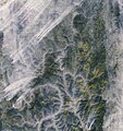
English: Wildfires break out in the boreal forests of eastern Russia most summers, but last year was particularly bad.
This image from the Copernicus Sentinel-2A satellite was taken on 28 September, and shows blazes that had plagued Russia’s Irkutsk Oblast since July. It is thought that drier conditions associated with warmer weather – with June 2016 being the hottest on record – contributed to the unusually large number of fires. A state of emergency was imposed on this area during the wildfires. Click on the box in the lower-right corner to view this image at its full 10 m resolution directly in your browser. Zooming in, we can see the fires appearing like small orange threads on the left and bottom of the image. Smoke billows from each fire and spreads across the landscape, becoming trapped in the valleys. Another visible feature is the Lena River snaking northeast. Boreal forests can be seen across the landscape. The boreal forest ecosystem, exclusive to the northern hemisphere, spans Russia, northern Europe, Canada and Alaska, comprising interrelated habitats made up of forests, lakes, wetlands, rivers and tundra. These forests, including their soil, store a third more carbon stocks per hectare as tropical forests, making them one of the most significant carbon stores in the world. While optical satellites like Sentinel-2 or Sentinel-3 can systematically monitor forests for change, such as from logging or other human activities, spaceborne radars can accurately measure forest biomass and how it varies. The dedicated Biomass satellite is currently being built, and is set to provide an easier and more accurate way to monitor this precious resource regularly to further our knowledge of the role played by forests in the carbon cycle. This image is featured on theEarth from Space video programme. |
| Дата | |
| Источник | http://www.esa.int/spaceinimages/Images/2017/05/Russian_wildfires |
| Автор | European Space Agency |
| Права (Повторное использование этого файла) |
contains modified Copernicus Sentinel data (2016), processed by ESA,CC BY-SA 3.0 IGO |
| Другие версии |
|
| Title InfoField | Russian wildfires |
| Set InfoField | Earth observation image of the week |
| System InfoField | Copernicus |
| Mission InfoField | Sentinel-2 |
| Location InfoField | Russia |
| Activity InfoField | Observing the Earth |
| Keywords InfoField | Fires; Forest; Forest fire; Satellite image |
Лицензирование
- Вы можете свободно:
- делиться произведением – копировать, распространять и передавать данное произведение
- создавать производные – переделывать данное произведение
- При соблюдении следующих условий:
- атрибуция – Вы должны указать авторство, предоставить ссылку на лицензию и указать, внёс ли автор какие-либо изменения. Это можно сделать любым разумным способом, но не создавая впечатление, что лицензиат поддерживает вас или использование вами данного произведения.
- распространение на тех же условиях – Если вы изменяете, преобразуете или создаёте иное произведение на основе данного, то обязаны использовать лицензию исходного произведения или лицензию, совместимую с исходной.


|
This image contains data from a satellite in the Copernicus Programme, such as Sentinel-1, Sentinel-2 or Sentinel-3. Attribution is required when using this image.
Атрибуция: Contains modified Copernicus Sentinel data {{{year}}}
Attribution
The use of Copernicus Sentinel Data is regulated under EU law (Commission Delegated Regulation (EU) No 1159/2013 and Regulation (EU) No 377/2014). Relevant excerpts:
Free access shall be given to GMES dedicated data [...] made available through GMES dissemination platforms [...].
Access to GMES dedicated data [...] shall be given for the purpose of the following use in so far as it is lawful:
GMES dedicated data [...] may be used worldwide without limitations in time.
GMES dedicated data and GMES service information are provided to users without any express or implied warranty, including as regards quality and suitability for any purpose. |
Attribution
Краткие подписи
Элементы, изображённые на этом файле
изображённый объект
26 мая 2017
История файла
Нажмите на дату/время, чтобы посмотреть файл, который был загружен в тот момент.
| Дата/время | Миниатюра | Размеры | Участник | Примечание | |
|---|---|---|---|---|---|
| текущий | 19:58, 30 мая 2017 |  | 9438 × 10 000 (540,07 Мб) | Fæ | European Space Agency, Id 377800, http://www.esa.int/spaceinimages/Images/2017/05/Russian_wildfires, User:Fæ/Project_list/ESA |
Использование файла
Следующая страница использует этот файл:
Метаданные
Файл содержит дополнительные данные, обычно добавляемые цифровыми камерами или сканерами. Если файл после создания редактировался, то некоторые параметры могут не соответствовать текущему изображению.
| Ширина | 9438 пикс. |
|---|---|
| Высота | 10 000 пикс. |
| Глубина цвета |
|
| Метод сжатия | Несжатый |
| Цветовая модель | RGB |
| Положение блока данных | 25 474 |
| Ориентация кадра | Нормальная |
| Количество цветовых компонентов | 3 |
| Количество строк в 1 блоке | 10 000 |
| Размер сжатого блока | 566 280 000 |
| Горизонтальное разрешение | 72 точек на дюйм |
| Вертикальное разрешение | 72 точек на дюйм |
| Принцип организации данных | формат «chunky» |
| Программное обеспечение | Adobe Photoshop CC 2017 (Macintosh) |
| Дата и время изменения файла | 09:41, 24 мая 2017 |
| Цветовое пространство | Некалиброванное |
